 FAO Map Catalog
Keyword
Land Resources
Type of resources
Available actions
Topics
Keywords
Contact for the resource
Provided by
status
Scale
From
1
-
10
/
35
-

Carte des ressources en sols de la Tunisie (feuille Zarzis)
-

Series: DOS 3113; Vegetation Map
-
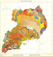
Include: Uganda Land Systems (1000000).
-

Includes: Land suitability for broadcast Irri Aus (Map 2)
-

Include: Sherpur; Jamalpur; Tangail (District map 5); Land use Map
-

Includes: Proportion of land suitable for transplanted Irri aman (Map 3)
-

Include: Goalanda; Faridpur; Madaripur; Sariatpur; Gopalganj (District map 9); Land use Map
-
Includes: Proportion of land suitable for cultivation of oilseeds (mainly groundnuts, mustard and rapeseed (Map 5)
-
Includes: Land development units (Map 7)
-

Includes: Additional crop production possible from introduction of irrigated Irri rice (Map 4)