 FAO Map Catalog
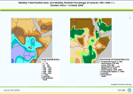
Rainfall Monitoring by Region for the African Continent: Eastern Africa
Maps on monthly total rainfall amount (in millimeters) and monthly rainfall percentage of normals 1961-1990 (in percentage) from August 2004 to October 2008 are available here for download for Eastern Africa. Rainfall data are also available in GeoNetwork for the whole African continent and the following Regions : Northern Africa, Western Africa, and Southern Africa.
An interpolation method (Kriging) is applied to input data.
Data input for rainfall maps are provided by Global Precipitation Climatology Centre (GPCC) operated by the Deutscher Wetterdienst (DWD, National Meteorological Service of Germany). GPCC First Guess Product, gauge-based gridded monthly precipitation data sets for the global land surface, at spatial resolutions of 1.0 x 1.0 degrees geographical latitude by longitude are used.
The First Guess Product of the monthly precipitation anomaly is based on interpolated precipitation anomalies from about 6,000 stations worldwide. Data sources are synoptic weather observation data (SYNOP) received at DWD via the WMO Global Telecommunication System (GTS) and climatic mean (mainly 1961-1990) monthly precipitation totals at the same stations extracted from GPCC s global normals collection. An automatic-only quality-control (QC) is applied to these data. Since September 2003, GPCC First Guess monthly precipitation analyses are available within 5 days after end of an observation month.
Simple
- Date ( Publication )
- 2008-12-04T11:19:00
- Edition
- Second
- Presentation form
- Digital map
- Purpose
- Regional crop monitoring and forecasting
- Status
- Completed
- Maintenance and update frequency
- As needed
- Keywords ( Theme )
-
- temperature
- precipitation
- agroclimatology
- Tag_climate
- Keywords ( Place )
-
- World
- Keywords
-
- Agromet
- Access constraints
- Copyright
- Spatial representation type
- Grid
- Metadata language
- eng
- Character set
- UTF8
- Topic category
-
- Climatology, meteorology, atmosphere
))
Vertical extent
- Reference system identifier
- WGS 1984
- Dimension name
- Row
- Dimension size
- 2160
- Resolution
- 1 Decimal Degree
- Dimension name
- Column
- Dimension size
- 4320
- Resolution
- 1 Decimal Degree
- Dimension name
- Vertical
- Cell geometry
- Area
- Transformation parameter availability
- No
- OnLine resource
-
Global Precipitation Climatology Centre (GPCC)
(
WWW:LINK-1.0-http--link
)
Global Precipitation Climatology Centre (GPCC)
- OnLine resource
-
EAf_raitot_raiper_2004.zip
(
WWW:DOWNLOAD-1.0-http--download
)
Monthly Rainfall for Eastern Africa - Year 2004
- OnLine resource
-
EAf_raitot_raiper_2005.zip
(
WWW:DOWNLOAD-1.0-http--download
)
Monthly Rainfall for Eastern Africa - Year 2005
- OnLine resource
-
EAf_raitot_raiper_2006.zip
(
WWW:DOWNLOAD-1.0-http--download
)
Monthly Rainfall for Eastern Africa - Year 2006
- OnLine resource
-
EAf_raitot_raiper_2007.zip
(
WWW:DOWNLOAD-1.0-http--download
)
Monthly Rainfall for Eastern Africa - Year 2007
- OnLine resource
-
EAf_raitot_raiper_2008.zip
(
WWW:DOWNLOAD-1.0-http--download
)
Monthly Rainfall for Eastern Africa - Year 2008
- OnLine resource
-
FAO Climpag - Crop and weather conditions by Region
(
WWW:LINK-1.0-http--link
)
FAO Climpag - Crop and weather conditions by Region
- OnLine resource
-
geonetwork:eaf_raitot_2008_10_36923
(
OGC:WMS-1.1.1-http-get-map
)
Monthly Total Rainfall for Eastern Africa - Year 2008 October
- OnLine resource
-
geonetwork:eaf_raiper_2008_9_36923
(
OGC:WMS-1.1.1-http-get-map
)
Percentage of Normal Rain for Eastern Africa - Year 2008 October
- Protocol
- OGC:WMS-1.1.1-http-get-map
- Protocol
- OGC:WMS-1.1.1-http-get-map
- Protocol
- OGC:WMS-1.1.1-http-get-map
- Protocol
- OGC:WMS-1.1.1-http-get-map
- Hierarchy level
- Dataset
gmd:MD_Metadata
- File identifier
- 801fa6ba-10a5-49d8-8b67-20ad81cf32a4 XML
- Metadata language
- eng
- Character set
- UTF8
- Date stamp
- 2019-11-22T10:23:20
- Metadata standard name
- ISO 19115:2003/19139
- Metadata standard version
- 1.0
Overviews

Spatial extent
Provided by
