 FAO Map Catalog
imageryBaseMapsEarthCover
Type of resources
Available actions
Topics
Keywords
Contact for the resource
Provided by
Years
Formats
Representation types
Update frequencies
status
Scale
Resolution
-
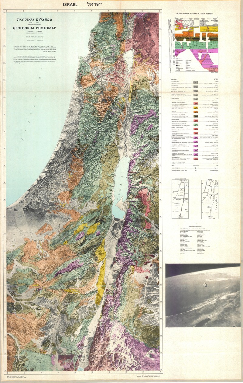
Special Publication No 2
-

The dataset represents spatially aggregated soil properties from the Harmonized World Soil Database v110, 0.5 degree spatial resolution. Contact the data publisher for detailed description of the aggregation method. Selected soil properties: AWC; AWC_Class; S_Clay; S_OC; S_Silt; S_Gravel; S_Sand; S_USDA_TEX; T_Clay; T_OC; T_Silt; T_Clay; T_OC; T_Silt; T_Gravel; T_Sand; T_USDA_TEX. This data set has been produced in the framework of the "Climate change predictions in Sub-Saharan Africa: impacts and adaptations (ClimAfrica)" project, Work Package 1 (WP1). WP1 (Past climate variability) aimed to provide consolidated data to other WPs in ClimAfrica, and to analyze the interactions between climate variability, water availability and ecosystem productivity of Sub-Saharan Africa. Various data streams that diagnose the variability of the climate, in particular the water cycle, and the productivity of ecosystems in the past decades, have been collected, analyzed and synthesized. The data streams range from ground-based observations and satellite remote sensing to model simulations. More information on ClimAfrica project is provided in the Supplemental Information section of this metadata.
-
A set of 6 medium scale (250k) topographic maps, that share geographical overlapping with the Okavango Basin. Source: The Surveyor General, Harare, Zimbabwe. Original data georeferenced under the GIS EPSMO program. This dataset is part of the GIS Database for the Environment Protection and Sustainable Management of the Okavango River Basin project (EPSMO). Detailed information on the database can be found in the “GIS Database for the EPSMO Project†document produced by Luis Veríssimo (FAO consultant) in July 2009, and here available for download.
-

Complete set of 16 medium scale topographic maps, that share geographical overlapping with the Okavango Basin. Source: Instituto de Geodesia e Cartografia de Angola (IGCA), Luanda. Original data georeferenced under the GIS EPSMO program. This dataset is part of the GIS Database for the Environment Protection and Sustainable Management of the Okavango River Basin project (EPSMO). Detailed information on the database can be found in the “GIS Database for the EPSMO Project†document produced by Luis Veríssimo (FAO consultant) in July 2009, and here available for download.
-

This dataset is a thematic reaggregated version of the original national Africover landcover multipurpose database. It contains all natural vegetation with a woody component. The original full resolution land cover has been produced from visual interpretation of digitally enhanced LANDSAT TM images (Bands 4,3,2) acquired mainly in the year 1997 (see the "Multipurpose Landcover Database" metadata for more details). This dataset is intended for free public access. Thematic aggregation is the way that the end user customizes the Africover database to fulfil his/her specific requirements. The Africover database gives equal level of detail to Agriculture as well as Natural vegetation or Bare Areas etc. Generally a single user does not need this level of detail for each class type; therefore he/she will enhance the information of one land cover type and will generalize or erase the information related to other land cover aspects. The most powerful way to conduct an aggregation exercise is to use the classifiers as basic elements of the exercise. This gives the user the maximum flexibility on the use of data. The shape main attributes correspond to the following fields: -ID -HECTARES -WOODY_ID -WOODY_DESC You can download a zip archive containing: -the tz-woody-agg (.shp) -the Tanzania Classifiers Used (.pdf) -the Tanzania legend (.pdf and .xls) -the Tanzania Legend - LCCS Import file (.xls) -the LCCSglossary_tanzania (.pdf) -the thematic-aggregation-procedure (.pdf) -the thematic-aggregation-annex1 (.pdf) -the thematic-aggregation-annex2 (.pdf) -the Userlabel Definitions (.pdf)
-

Town lands in Namibia, that share geographical overlapping with the Okavango Basin. Source: Ministry of Agriculture, Water and Forestry of Namibia. This dataset is part of the GIS Database for the Environment Protection and Sustainable Management of the Okavango River Basin project (EPSMO). Detailed information on the database can be found in the “GIS Database for the EPSMO Project†document produced by Luis Veríssimo (FAO consultant) in July 2009, and here available for download.
-

This dataset is a thematic reaggregated version of the original national Africover landcover multipurpose database. It contains all cultivated land. The original full resolution land cover has been produced from visual interpretation of digitally enhanced LANDSAT TM images (Bands 4,3,2) acquired mainly in the period 2000-2001 (see the "Multipurpose Landcover Database" metadata for more details). This dataset is intended for free public access. Thematic aggregation is the way that the end user customizes the Africover database to fulfil his/her specific requirements. The Africover database gives equal level of detail to Agriculture as well as Natural vegetation or Bare Areas etc. Generally a single user does not need this level of detail for each class type; therefore he/she will enhance the information of one land cover type and will generalize or erase the information related to other land cover aspects. The most powerful way to conduct an aggregation exercise is to use the classifiers as basic elements of the exercise. This gives the user the maximum flexibility on the use of data. The shape main attributes correspond to the following fields: -ID -HECTARES -CULT_ID -CULT_DESC You can download a zip archive containing: -the ug-cultiv-agg (.shp) -the Uganda Classifiers Used (.pdf) -the Uganda legend (.pdf and .xls) -the Uganda Legend - LCCS Import file (.xls) -the LCCSglossary_uganda (.pdf) -the thematic-aggregation-procedure (.pdf) -the thematic-aggregation-annex1 (.pdf) -the thematic-aggregation-annex2 (.pdf) -the Userlabel Definitions (.pdf)
-

This dataset is a thematic reaggregated version of the original national Africover landcover multipurpose database. It contains all natural vegetation with a herbaceous component. The original full resolution land cover has been produced from visual interpretation of digitally enhanced LANDSAT TM images (Bands 4,3,2) acquired mainly in the period 2000-2001 (see the "Multipurpose Landcover Database" metadata for more details). This dataset is intended for free public access. Thematic aggregation is the way that the end user customizes the Africover database to fulfil his/her specific requirements. The Africover database gives equal level of detail to Agriculture as well as Natural vegetation or Bare Areas etc. Generally a single user does not need this level of detail for each class type; therefore he/she will enhance the information of one land cover type and will generalize or erase the information related to other land cover aspects. The most powerful way to conduct an aggregation exercise is to use the classifiers as basic elements of the exercise. This gives the user the maximum flexibility on the use of data. The shape main attributes correspond to the following fields: -ID -HECTARES -GRASS_ID -GRASS_DESC You can download a zip archive containing: -the ug-grass-agg (.shp) -the Uganda Classifiers Used (.pdf) -the Uganda legend (.pdf and .xls) -the Uganda Legend - LCCS Import file (.xls) -the LCCSglossary_uganda (.pdf) -the thematic-aggregation-procedure (.pdf) -the thematic-aggregation-annex1 (.pdf) -the thematic-aggregation-annex2 (.pdf) -the Userlabel Definitions (.pdf)
-

This dataset is a thematic reaggregated version of the original national Africover landcover multipurpose database. It contains all natural vegetation with a woody component. The original full resolution land cover has been produced from visual interpretation of digitally enhanced LANDSAT TM images (Bands 4,3,2) acquired mainly in the period 2000-2001 (see the "Multipurpose Landcover Database" metadata for more details). This dataset is intended for free public access. Thematic aggregation is the way that the end user customizes the Africover database to fulfil his/her specific requirements. The Africover database gives equal level of detail to Agriculture as well as Natural vegetation or Bare Areas etc. Generally a single user does not need this level of detail for each class type; therefore he/she will enhance the information of one land cover type and will generalize or erase the information related to other land cover aspects. The most powerful way to conduct an aggregation exercise is to use the classifiers as basic elements of the exercise. This gives the user the maximum flexibility on the use of data. The shape main attributes correspond to the following fields: -ID -HECTARES -WOODY_ID -WOODY_DESC You can download a zip archive containing: -the drc-cult-agg (.shp) -the DR Congo Classifiers Used (.pdf) -the DR Congo legend (.pdf and .xls) -the DR Congo Legend - LCCS Import file (.xls) -the LCCSglossary_drcongo (.pdf) -the thematic-aggregation-procedure (.pdf) -the thematic-aggregation-annex1 (.pdf) -the thematic-aggregation-annex2 (.pdf) -the Userlabel Definitions (.pdf)
-

This dataset is a thematic reaggregated version of the original national Africover landcover multipurpose database. It contains all natural vegetation with a herbaceous component. The original full resolution land cover has been produced from visual interpretation of digitally enhanced LANDSAT TM images (Bands 4,3,2) acquired mainly in the year 1999 (see the "Multipurpose Landcover Database" metadata for more details). This dataset is intended for free public access. Thematic aggregation is the way that the end user customizes the Africover database to fulfil his/her specific requirements. The Africover database gives equal level of detail to Agriculture as well as Natural vegetation or Bare Areas etc. Generally a single user does not need this level of detail for each class type; therefore he/she will enhance the information of one land cover type and will generalize or erase the information related to other land cover aspects. The most powerful way to conduct an aggregation exercise is to use the classifiers as basic elements of the exercise. This gives the user the maximum flexibility on the use of data. The shape main attributes correspond to the following fields: -ID -HECTARES -GRASS_ID -GRASS_DESC You can download a zip archive containing: -the rw-grass-agg (.shp) -the Rwanda Classifiers Used (.pdf) -the Rwanda legend (.pdf and .xls) -the Rwanda Legend - LCCS Import file (.xls) -the LCCS glossary_rwanda(.pdf) -the thematic-aggregation-procedure (.pdf) -the thematic-aggregation-annex1 (.pdf) -the thematic-aggregation-annex2 (.pdf) -the Userlabel Definitions (.pdf)