 FAO Map Catalog
elevation
Type of resources
Available actions
Topics
Keywords
Contact for the resource
Provided by
Years
Formats
Representation types
Update frequencies
status
Scale
-
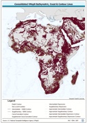
Seamless and topologically robust derivative of all linear VMap0 - Ed3 bathymetric, coastline, and terrain contour data layers. The HYPSO_LN shapefile data layer is comprised of 108715 derivative vector framework library features derived based on 1:1 000 000 data originally from VMap0 | 5th Edition. The layer provides nominal analytical/mapping at 1:1 000 000. Data processing 75% complete globally, with African subset 100% complete. Acronyms and Abbreviations: VMap0 - Vector Map for Level 0.
-
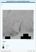
Volta Basin SRTM 3 as Based Hillshade Mosaic. SRTM is Shuttle Radar Topography Mission. The HSHD_MOS grid data layer is comprised of 13201x14401 derivative raster hillshade features derived based on 0.000833_ data originally from SRTM 3as v.2.
-
Derivative of the above "Null" SRTM 3-arc second dataset with terrestrial void areas backfilled with SRTM-GTopo30 DEM, 3204 Arc-Grid tiles. Source: FAO
-
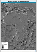
ETOPO2 2 arc-minute Hill-Bathymetric Shading. ETOPO2 is a 2 minute Elevation Topographic DEM including bathymetry. The ETOPO2_HSHD grid data layer is comprised of 5400x10800 derivative raster hillshade | bathymetry features derived based on 0.03333_ data originally from ETOPO2. The layer provides nominal analytical/mapping at 1:12 500 000. Acronyms and Abbreviations: ETOPO2 - A 2 minute Elevation Topographic DEM including bathymetry; DEM - Digital Elevation Model.
-
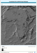
Grid based hillshade of consolidated 30 as SRTM-ETopo2 DEM. SRTM is Shuttle Radar Topography Mission; DEM is Digital Elevation Model; ETOPO2 is a 2 minute Elevation Topographic DEM including bathymetry.. The HSHDBATH grid data layer is comprised of 10800x11400 derivative raster hillshade features derived based on 0.00833_ data originally from SRTM 30as v.2.
-
Arc-Grid based hillshaded depiction of NASA 3as SRTM Version 2 for Africa, seamless compilation of 3 204 1x1 overlapping tiles. The SRTM-3AS_IMGCAT_HSHD image data layer is comprised of 3204 derivative calculated seamless image catalog features derived based on 0.000833_ data originally from FAO. SRTM (Shuttle Radar Topography Mission)
-
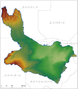
Digital Terrain Model within the Okavango Basin. Source: Data generated under the GIS EPSMO program (base:SRTM data). This dataset is part of the GIS Database for the Environment Protection and Sustainable Management of the Okavango River Basin project (EPSMO). Detailed information on the database can be found in the “GIS Database for the EPSMO Project†document produced by Luis Veríssimo (FAO consultant) in July 2009, and here available for download.
-
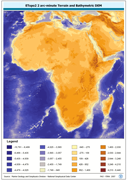
ETOPO2 2 arc-minute Terrain and Bathymetric DEM. The ETOPO2 grid data layer is comprised of 5400x10800 derivative raster bathymetry features derived based on 0.03333_ data originally from ETOPO2. Acronyms and Abbreviations: ETOPO2 - A 2 minute Elevation Topographic DEM including bathymetry DEM - Digital Elevation Model
-
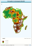
WRIA_DEM: Hydrologically filled GTopo30 DEM with the main stems of cartographic rivers "burned-in" for irrigation analysis. GT30/GTopo30 is Global Topographic 30 arc second DEM database, nominal 1km postings; DEM is Digital Elevation Model. The WRIALAEA grid data layer is comprised of 9194x8736 derivative raster hydrologically filled dem features derived based on 1 kilometer data originally from FAO.
-

Robust derivative of VMap0 - Ed5 data layers with harmonized encoding. The HYPSO_PT shapefile data layer is comprised of 80449 derivative vector framework library features derived based on 1:1 000 000 data originally from VMap0, 5th Edition. The layer provides nominal analytical/mapping at 1:1 000 000. Data processing 75% complete globally, with African subset 100% complete. Acronyms and Abbreviations: VMap0 - Vector Map for Level 0.