 FAO Map Catalog
climatologyMeteorologyAtmosphere
Type of resources
Available actions
Topics
Keywords
Contact for the resource
Provided by
Years
Formats
Representation types
Update frequencies
status
Scale
Resolution
-
The Food and Agriculture Organization of the United Nations (FAO) with the collaboration of the International Institute for Applied Systems Analysis (IIASA), has developed a system that enables rational land-use planning on the basis of an inventory of land resources and evaluation of biophysical limitations and potentials. This is referred to as the Agro-ecological Zones (AEZ) methodology.
-
Consolidated Table of 7 Year Short Average Decadal Rainfall. The RFE_SAVG tabular data layer is comprised of 471688 derivative raster precipitation features derived based on 8 kilometers data originally from EDC. The layer provides nominal analytical/mapping at 1:3 500 000. Acronyms and Abbreviations: EDC - USGS EROS (Earth Resources Observation Systems) Data Center.
-

The Climate Change ATLAS (CSIC) provides climate change information for essential climate variables generated from CMIP and CORDEX international initiatives. The data cubes for CMIP5 precipitation projectons provide gridded projections with a 2 deg spatial resolution as 1) relative differences (%) for three reference future periods (2021-2040, 2041-2060, 2080-2100) for RCP 2.6 an 8.5 scenarios with respect to the baseline reference period 1981-2010, and 2) relative differences (%) corresponding to three Global Warming Levels (1.5, 2 and 3 degC, obtained from the RCP8.5 scenario), with respect to preindustrial values (as characterized by the 1850-1900 period). Geospatial data from the ensemble of CMIP5 models represents the ensemble mean. The list of models used is available at https://github.com/SantanderMetGroup/ATLAS/tree/master/AtlasHub-inventory
-
Consolidated Table of CRU Evapotranspiration. The ET_MNTHY tabular data layer is comprised of 92717 derivative raster evapotranspiration features derived based on 0.16667_ data originally from CRU. The layer provides nominal analytical/mapping at 1:70 000 000. Acronyms and Abbreviations: CRU - Climatic Research Unit - School of Environmental Sciences, University of East Anglia - Norwich.
-

A set of 15 raster layers representing the monthly, annual, mean and average temperature for the Okavango Rive Basin. Source: Africa Water Resources Database (FAO). This dataset is part of the GIS Database for the Environment Protection and Sustainable Management of the Okavango River Basin project (EPSMO). Detailed information on the database can be found in the “GIS Database for the EPSMO Project†document produced by Luis Veríssimo (FAO consultant) in July 2009, and here available for download.
-
Consolidated Table of 1999 Decadal Rainfall. The RFE_1999 tabular data layer is comprised of 471688 derivative raster precipitation features derived based on 8 kilometers data originally from EDC. The layer provides nominal analytical/mapping at 1:3 500 000. Acronyms and Abbreviations: EDC - USGS EROS (Earth Resources Observation Systems) Data Center.
-
As part of the the World Bank's review of its rural development strategy, the Bank sought the assistance of the Food and Agriculture Organization of the United Nations (FAO) in evaluating how farming systems might change and adapt over the next thirty years. Amongst other objectives, the World Bank asked FAO to provide guidance on priorities for investment in food security, poverty reduction, and economic growth, and in particular to identify promising approaches and technologies that will contribute to these goals. The results of the study are summarized in a set of seven documents, comprising six regional reports and the global overview contained in this volume. This document, which synthesises the results of the six regional analyses as well as discussing global trends, cross-cutting issues and possible implementation modalities, presents an overview of the complete study. This document is supplemented by two case study reports of development issues of importance to farming systems globally.
-
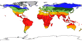
The thermal climates represent major latitudinal climatic zones. They were obtained through classifying monthly temperatures corrected to sea level (with an assumed lapse rate: 0.55°C/100m). The latitudinal thermal climates distinguished in global AEZ are the following: tropics, subtropics with summer rainfall, subtropics with winter rainfall, temperate, boreal and polar/arctic. The temperate and boreal belts have been further subdivided according to continentality into three classes, namely: oceanic, sub-continental and continental. Data derived from analysis over 37 years.
-
Consolidated Table of 2003 Decadal Rainfall. The RFE_2003 tabular data layer is comprised of 471688 derivative raster precipitation features derived based on 8 kilometers data originally from EDC. The layer provides nominal analytical/mapping at 1:3 500 000. Acronyms and Abbreviations: EDC - USGS EROS (Earth Resources Observation Systems) Data Center.
-

A Decadal prediction data set of several atmospheric and oceanic variables is here presented for climate studies and comparisons. Predictions are performed one time every 5 years, with start date on Nov 1st, and integrated for twenty years. Each prediction is constituted of three ensemble members to have a minimal sample of the uncertainty on the initial conditions. The sampled variables are: The sampled variables are: - Specific Humidity (Q) - Relative Humidity (RH) - Temperature (T) - Zonal Wind (U) - Meridional Wind (V) - Surface temperature (surf_temp) - Zonal Wind at 10m (u10) - Meridional Wind at 10m (v10). The decadal predictions data are available for download on demand only. Please contact Andrea Borrelli at andrea.borrelli@cmcc.it to place your request. This data set has been produced in the framework of the "Climate change predictions in Sub-Saharan Africa: impacts and adaptations (ClimAfrica)" project, Work Package 2 (WP2). More information on ClimAfrica project is provided in the Supplemental Information section of this metadata.