 FAO Map Catalog
boundaries
Type of resources
Available actions
Topics
Keywords
Contact for the resource
Provided by
Years
Formats
Representation types
Update frequencies
status
Scale
Resolution
-
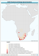
Threatened to endangered species watershed boundaries based SAIAB and HYDRO1k. Source: SAIAB and HYDRO1k, "river" flow, and watershed networks based on the GTopo30. The AQSP_THRTND_PY shapefile data layer is comprised of 92 derivative polygon aquatic species features derived based on 1:2 000 000 data originally from SAIAB. The layer provides nominal analytical/mapping at 1:2 000 000. Acronyms and Abbreviations: SAIAB - South African Institute for Aquatic Biodiversity; HYDRO1k - Global Hydrological 1 kilometre database of hydrologically filled DEMs; DEM - Digital Elevation Model; GT30/GTopo30 - Global Topographic 30 arc second DEM database, nominal 1km postings.
-
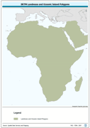
Seamless polygonal continental landmass and oceanic island mask data layer derived from SRTM-SWBD tiled database. The MASK_PY shapefile data layer is comprised of 4333 derivative vector surface water bodies features derived based on 1:100 000 data originally from SRTM-SWBD. The layer provides nominal analytical/mapping at 1:125 000. Data processing 60% complete globally, with African and Arabian subsets 100% complete. Acronyms and Abbreviations: SRTM - Shuttle Radar Topography Mission; SWBD - Surface water Body.
-
This dataset represents the second-level administrative unit 'Cantons' of Ecuador. The dataset was uploaded by the Military Geographic Institute of Ecuador in February 2020 to Second Administrative Level Boundaries (SALB) Program of United Nations. The reference scale for this Geospatial data is equivalent to 1:1,000,000 scale, or larger scale. Data was downloaded from UN-SALB site in September 2022, feature topology/geometry was corrected, international borders validated against the United Nations official borders (United Nations Geospatial Information Section - UN-Map 2018). The dataset is part of FAO's Hand-in-Hand (HiH) second administrative level boundaries 2022 dataset series, published on the HiH Geospatial Platform for thematic mapping, integration of geospatially enabled statistics, zonal statistics extraction, and used for HiH initiative geospatial analysis (GIS-MCDA, suitability/location analysis, agricultural typologies).
-
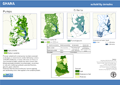
This map shows areas suitable for the Agricultural Water Management interventions as identified by the project. The assessment is based primarily on each intervention's bio-physical requirements (such as: climate, proximity to water resources, terrain), but it also includes a qualitative rating based on infrastructural settings (namely distance to markets).
-

Road network in Africa classified according to their accompanying road type classification system. The cost grid represents the time cost and it is assumed that the time required to travel from one cell to another in absence of main roads is 5 times longer than the time needed on the main road. Road network was derived from ArcWorld (ESRI, 1992).
-

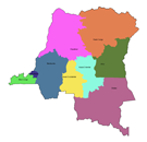
This layer represents the political administration level 1 boundaries (level of municipality, (Region) and subdistrict) in the 4 riparian countries, that share geographical overlapping with the Okavango Basin: Angola, Namibia, Botswana and Zimbabwe. Source: Generated under the GIS EPSMO program. This dataset is part of the GIS Database for the Environment Protection and Sustainable Management of the Okavango River Basin project (EPSMO). Detailed information on the GIS Database can be found in the “GIS Database for the EPSMO Project†document produced by Luis Veríssimo (FAO consultant) in July 2009, and here available for download.
-
This dataset represents the second-level administrative unit 'Arrondissements' of Haiti. As of 2015, the 10 departments of Haiti were divided into 41 arrondissements. The dataset was uploaded by the Centre National de l'information Geo-Spatiale, Haiti in October 2019 for Second Administrative Level Boundaries (SALB) Program of United Nations. The reference scale for this Geospatial data is equivalent to 1:1,000,000 scale, or larger scale. Data was downloaded from UN-SALB site in May 2022, feature topology/geometry was corrected, international borders validated against the United Nations official borders (United Nations Geospatial Information Section - UN-Map 2018). The dataset is part of FAO's Hand-in-Hand (HiH) second administrative level boundaries 2022 dataset series, published on the HiH Geospatial Platform for thematic mapping, integration of geospatially enabled statistics, zonal statistics extraction, and used for HiH initiative geospatial analysis (GIS-MCDA, suitability/location analysis, agricultural typologies).
-
The national and administrative boundaries have been taken from the DCW dataset. Coastlines have been adapted to match the landcover dataset.
-

This map shows areas suitable for the Agricultural Water Management interventions as identified by the project. The assessment is based primarily on each intervention's bio-physical requirements (such as: climate, proximity to water resources, terrain), but it also includes rating based on socio-economic settings or infrastructure (namely distance to markets). Details of criteria and threshold used are given in the downloadable files.
-

Grids with monthly values of coefficient of variation of precipitation for the period 1961-1990, at 5 arc min. Based on: New, M., Lister, D., Hulme, M. and Makin, I., 2002: A high-resolution data set of surface climate over global land areas. Climate Research 21:1-25