 FAO Map Catalog
Marine Geology and Geophysics Division - National Geophysical Data Center
Type of resources
Available actions
Topics
Keywords
Contact for the resource
Provided by
Years
Representation types
Update frequencies
status
Scale
-
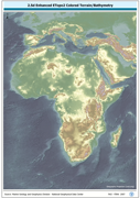
RGB color image of nominal 3.7 Km bathymetry and terrestrial elevation values. RGB is 3 band spatial imagery forced into the Red:Green:Blue spectrum. The ETOPO2_2-5D image data layer is comprised of 5400x10800 derivative raster bathymetry features derived based on 0.03333_ data originally from ETOPO2.
-
Grayscale image of nominal 3.7 Km bathymetry and terrestrial elevation values. The ETOPO2_SHD image data layer is comprised of 5400x10800 derivative raster hillshade | bathymetry features derived based on 0.03333_ data originally from ETOPO2.
-
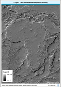
ETOPO2 2 arc-minute Hill-Bathymetric Shading. ETOPO2 is a 2 minute Elevation Topographic DEM including bathymetry. The ETOPO2_HSHD grid data layer is comprised of 5400x10800 derivative raster hillshade | bathymetry features derived based on 0.03333_ data originally from ETOPO2. The layer provides nominal analytical/mapping at 1:12 500 000. Acronyms and Abbreviations: ETOPO2 - A 2 minute Elevation Topographic DEM including bathymetry; DEM - Digital Elevation Model.
-
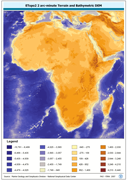
ETOPO2 2 arc-minute Terrain and Bathymetric DEM. The ETOPO2 grid data layer is comprised of 5400x10800 derivative raster bathymetry features derived based on 0.03333_ data originally from ETOPO2. Acronyms and Abbreviations: ETOPO2 - A 2 minute Elevation Topographic DEM including bathymetry DEM - Digital Elevation Model
-
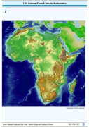
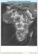
A Shaded relief image based on the first globally available elevation model. The AFRICA_BACKGROUND image data layer is comprised of 973x985 derivative raster bathymetry and elevation features derived based on 0.08333_ data originally from ETOPO5.
-

RGB color image of nominal 3.7 Km bathymetry and terrestrial elevation values. RGB is 3 band spatial imagery forced into the Red:Green:Blue spectrum. The ETOPO2_RGB image data layer is comprised of 5400x10800 derivative raster bathymetry features derived based on 0.03333_ data originally from ETOPO2.