 FAO Map Catalog
FAO-UN Consultant
Type of resources
Topics
Keywords
Contact for the resource
Provided by
Years
Formats
Representation types
Update frequencies
status
-
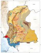
This dataset provides information on the land cover distribution in the Sindh province. The Provincial land cover database of Sindh was made possible by the contributions of the partner organizations involved in the project "Agricultural Information System - Building Provincial Capacity in Pakistan for Crop Estimation, Forecasting, and Reporting based on the integral use of Remotely Sensed Data, GCP/PAK/125/USA", the Government of Pakistan, the Food and Agriculture Organization of the United Nations (FAO) and the United States Department of Agriculture (USDA), which funds the Project. The database was created using a number of data sources ranging from remote sensing satellite imagery (at 5 meters resolution or better), available historical digital datasets and in-situ data. The FAO Land Cover Classification System (LCCS) was used for the creation of the national legend in consultation and inputs from the national experts. The legend has 13 main land cover classes which have been further subdivided into 36 classes mapped based on the analysis, interpretation and validation of SPOT -5 very high resolution satellite data (5 metre). The SPOT-5 satellite images were segmented into homogeneous polygons and labeled using the LCCS classification system and adopting the FAO methodology and its land cover toolbox.