 FAO Map Catalog
Contact for the resource
FAO and USGS - U.S. Department of the Interior, U.S. Geological Survey, Reston, VA, USA
Type of resources
Available actions
Topics
Keywords
Contact for the resource
Provided by
Representation types
Update frequencies
status
From
1
-
1
/
1
-
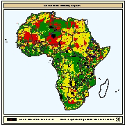
Suitable areas for the construction of fishponds based on the combined suitability of soils and slopes. Soils evaluation was based on FAO's Digital Soil Map of the World (DSMW) and included: texture, effective soil depth, pH, salinity, and the presence of catclays and gypsum. Slope was derived from a global digital elevation model (GTOPOP30) in the form of percentages. To consider the combined suitability of soils and slopes, it was considered that the former were more important than the latter. This was because suitable soils would ensure two of the most important engineering capability factors for pond construction: good water retention and good pond fertility