 FAO Map Catalog
Centre Tecnologic Forestal de Catalunya (CTFC)
Type of resources
Available actions
Topics
Keywords
Contact for the resource
Provided by
Years
Formats
Representation types
Update frequencies
status
-

The dataset includes a set of socio-economic field collected data in a wide range of Sub-Saharan African communities. The main parameters include: · Historical climate events (description of main climatic events described by the surveyed communities); · Mental models (conceptual understanding of climate change as perceived by local communities); · Participatory risk mapping (main risks/hazards to livelihood perceived by local communities); · Stakeholders analysis (identification of institutional structures that come into force under environmental stress); · Household demographics; · General household livelihood portfolio; · Household vulnerability mapping (identification of main stressors at household level); This set of data has been produced in the framework of the "Climate change predictions in Sub-Saharan Africa: impacts and adaptations (ClimAfrica)" project, Work Package 6 (WP6). For more information on the following work packages produced, please contact the data originator indicated in the Point of contacts section of this metadata. • Project Deliverable D6.1 - Catalogue of selected watersheds for the case studies. • Project Deliverable D6.2 - Reports on site characteristics of the model areas using a standardized format. • Project Deliverable D6.3 - Database of relevant eddy covariance measurements from the available CarboAfrica (FP6 project) flux sites to be delivered to WP1 and WP2 for model development. • Project Deliverable D6.4 - High spatial and temporal resolution time series combining high and medium spatial resolution satellite data for assimilation and phenological modelling.
-
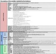
The database includes a set of field collected biophysical parameters in a wide range of Sub-Saharan African agroecosystems. The main parameters include: · Current and past land use category, with approximate date of change (if any); · Main climatic parameters, obtained from the closest weather station; · Type of underlying bedrock; · A set of topographical variables: altitude, slope, aspect, macrotopography and microtopography; · General fertilization information (if any); · General grazing management (if any); · General crop management (sown species, rotation, irrigation, etc.); · Soil data (including texture, bulk density, C, N, P, pH, CEC, etc); · Vegetation biomass; · Vascular species richness. Sampling plots and boundaries of study areas are available as digital maps in the "Distribution" section of this metadata. This set of data has been produced in the framework of the "Climate change predictions in Sub-Saharan Africa: impacts and adaptations (ClimAfrica)" project, Work Package 6 (WP6). For more information on the following work packages produced, please contact the data originator indicated in the Point of contacts section of this metadata. • Project Deliverable D6.1 - Catalogue of selected watersheds for the case studies. • Project Deliverable D6.2 - Reports on site characteristics of the model areas using a standardized format. • Project Deliverable D6.3 - Database of relevant eddy covariance measurements from the available CarboAfrica (FP6 project) flux sites to be delivered to WP1 and WP2 for model development. • Project Deliverable D6.4 - High spatial and temporal resolution time series combining high and medium spatial resolution satellite data for assimilation and phenological modelling.