 FAO Map Catalog
Contact for the resource
AQUASTAT - FAO-UN Land and Water Division
Type of resources
Available actions
Topics
Keywords
Contact for the resource
Provided by
Representation types
Update frequencies
status
Scale
From
1
-
1
/
1
-
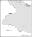
Location of large irrigation schemes, in Namibia, that share geographical overlapping with the Okavango Basin. Source: Ministry of Agriculture, Water and Forestry of Namibia. This dataset is part of the GIS Database for the Environment Protection and Sustainable Management of the Okavango River Basin project (EPSMO). Detailed information on the database can be found in the GIS Database for the EPSMO Project document produced by Luis Veríssimo (FAO consultant) in July 2009, and here available for download.