 FAO Map Catalog
watersheds
Type of resources
Available actions
Topics
Keywords
Contact for the resource
Provided by
Years
Formats
Representation types
Update frequencies
status
Scale
-
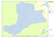
Awash River Basin boundary used for the project GCP/GLO/207/ITA
-
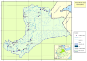
Awash River Basin hydrographic data used for the project GCP/GLO/207/ITA, including rivers, lakes and hydrographic stations within the basin.
-
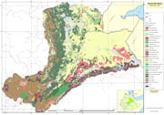
Awash River Basin land cover data used for the project GCP/GLO/207/ITA. Source Ministry of Agriculture and Rural Development.
-

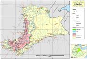
Survey points of small irrigation schemes with attributes, existing large irrigation schemes polygons, and location of existing small/medium schemes from secondary data review. Further info available at: http://www.mowr.gov.et/AWMISET/Index.php Output of project GCP/GLO/207/ITA Data downloadable upon permission given by owner (Ethiopian Ministry of Water and Energy). Please contact the data distributor or any other points of contact associated to this metadata.
-
Awash River Basin climatic data used for the project GCP/GLO/207/ITA. The dataset includes: agroecological zones, meteorological stations, rainfall isohyets. Data downloadable upon permission given by owner (Ethiopian Ministry of Water and Energy). Please contact the data distributor or any other points of contact associated to this metadata.
-
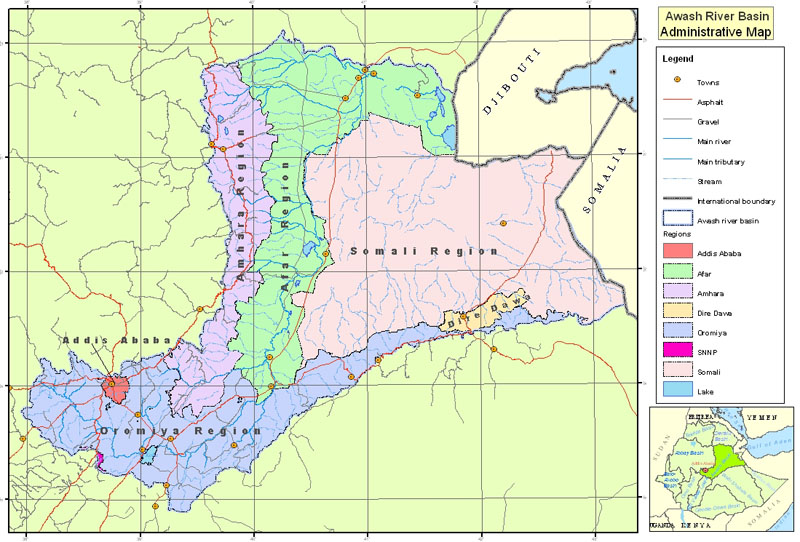
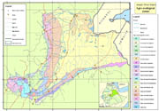
Administrative areas, roads and settlements in Awash River Basin, used for the project GCP/GLO/207/ITA
-
Wereda (administrative units) covered by pilot survey of irrigation schemes for the project GCP/GLO/207/ITA
-
This dataset divides the South Sudan according to its hydrological characteristics: major hydrological basins and their sub-basins It identifies eighteen sub-basins as follows: Akoba, Bahr al arab, Buhayrat abyad, Gelha, Khawr biban, Khawr tunbak, Khawr_marchar, Kidepo, Kwahr as sidrah, Kwahr mâ boloko, Lake turkana, Lotagipi swamp, Sopo, Sue, White nile 3, White nile 4, White nile 5 and White nile 6. The dataset provides information on: numerical code and name of the major basin (MAJ_BAS and MAJ_NAME); - area of the major basin in square km (MAJ_AREA); and numerical code and name of the sub-basin (SUB_BAS and SUB_NAME). The dataset comes from the HydroSHEDS (Hydrological data and maps based on SHuttle Elevation Derivatives at multiple Scales) of the US Geological Survey. The USGS HydroSHEDS is based on high-resolution elevation data obtained during a Space Shuttle flight of NASAâs Shuttle Radar Topography Mission (SRTM). Around twenty-three sub-basins fall in the South Sudan area, including five sub-basins of which only a small portion is comprised. They are part of two main hydrological basins: the biggest part of the study area belongs to the Nile basin, while the eastern part of the area belongs to the Rift Valley basin. The delineation of the hydrological basins can be considered as the starting point in the analysis of the hydrological cycle to study surface water resources systems.
-

H1k_WS: 6-level watershed model based on the HYDRO1k, reprojected, verified, and downstream encoded version of the 6th level Pfafstetter encoded H1k watersheds. The H1K_LEV6 shapefile data layer is the comprised of 7133 derivative raster watershed and flow network features derived based on 4 000 cell data originally from HYDRO1k. The layer provides nominal analytical/mapping at 1:2 000 000. Data processing is complete globally, this is an African subset. Acronyms and Abbreviations: HYDRO1k - Global Hydrological 1 kilometre database of hydrologically filled DEMs, "river" flow, and watershed networks based on the GTopo30; GTopo30 - GT30/GTopo30 - Global Topographic 30 arc second DEM database, nominal 1km postings.
-
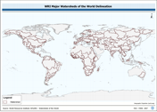
WRIBASIN: Watersheds of the World published by the World Resources Institute, a cleaned version of this watershed delineation enhanced to include WRI's original publication attributes. The WRIBASIN shapefile data layer is comprised of 254 derivative vector major river basins features derived based on ~250 000 cell data originally from WRI-Rutgers. Data processing is complete globally, this is an African subset. Acronyms and Abbreviations: WRI - World Resources Institute.