 FAO Map Catalog
Yield
Type of resources
Available actions
Topics
Keywords
Contact for the resource
Provided by
Formats
Representation types
Update frequencies
status
-
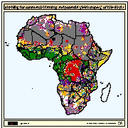
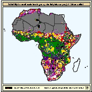
Map derived from the combined suitability of areas apt for commercial fish farming development and operation with areas with potential yield (crops/y) of Nile tilapia for commercial farming. Areas with suitability for commercial fish farming were derived from the combined suitability of five land-quality factors important for fish farming development and operation; net annual water requirement for shallow ponds, soil and terrain suitability for the construction of fish ponds, potential livestock wastes and agriculture by-products as feed and fertilizer inputs, potential for farm-gate sales and potential market demand. Predictions of growth were based on water temperature, in turn predicted from air temperature and wind velocity data. Gridded values of mean monthly daily minimum and maximum temperatures were obtained from the Centre for Resource and Environmental Studies (CRES) at the Australian National University. Mean annual wind velocity was obtained from UNEP/DEIA/GRID-Geneva.
-
Map derived from the combined suitability of areas apt for small-scale fish farming development and operation with areas with potential yield (crops/y) of Nile tilapia, African catfish and Common carp for small-scale farming. Areas with suitability for small-scale fish farming were derived from the combined suitability of four land-quality factors important for fish farming development and operation; net annual water requirement for shallow ponds, soil and terrain suitability for the construction of fish ponds, potential livestock wastes and agriculture by-products as feed and fertilizer inputs, and potential for farm-gate sales. Predictions of growth were based on water temperature, in turn predicted from air temperature and wind velocity data. Gridded values of mean monthly daily minimum and maximum temperatures were obtained from the Centre for Resource and Environmental Studies (CRES) at the Australian National University. Mean annual wind velocity was obtained from UNEP/DEIA/GRID-Geneva.
-
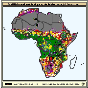
Map derived from the combined suitability of areas apt for commercial fish farming development and operation with areas with potential yield (crops/y) of Common carp for commercial farming. Areas with suitability for commercial fish farming were derived from the combined suitability of five land-quality factors important for fish farming development and operation; net annual water requirement for shallow ponds, soil and terrain suitability for the construction of fish ponds, potential livestock wastes and agriculture by-products as feed and fertilizer inputs, potential for farm-gate sales and potential market demand. Predictions of growth were based on water temperature, in turn predicted from air temperature and wind velocity data. Gridded values of mean monthly daily minimum and maximum temperatures were obtained from the Centre for Resource and Environmental Studies (CRES) at the Australian National University. Mean annual wind velocity was obtained from UNEP/DEIA/GRID-Geneva.
-
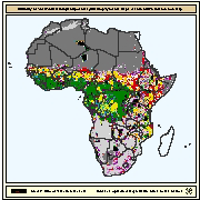
Map derived from the combined suitability of areas apt for small-scale fish farming development and operation with areas with potential yield (crops/y) of Nile tilapia for small-scale farming. Areas with suitability for small-scale fish farming were derived from the combined suitability of four land-quality factors important for fish farming development and operation; net annual water requirement for shallow ponds, soil and terrain suitability for the construction of fish ponds, potential livestock wastes and agriculture by-products as feed and fertilizer inputs, and potential for farm-gate sales. Predictions of growth were based on water temperature, in turn predicted from air temperature and wind velocity data. Gridded values of mean monthly daily minimum and maximum temperatures were obtained from the Centre for Resource and Environmental Studies (CRES) at the Australian National University. Mean annual wind velocity was obtained from UNEP/DEIA/GRID-Geneva.
-
Map derived from the combined suitability of areas apt for small-scale fish farming development and operation with areas with potential yield (crops/y) of African catfish for small-scale farming. Areas with suitability for small-scale fish farming were derived from the combined suitability of four land-quality factors important for fish farming development and operation; net annual water requirement for shallow ponds, soil and terrain suitability for the construction of fish ponds, potential livestock wastes and agriculture by-products as feed and fertilizer inputs, and potential for farm-gate sales. Predictions of growth were based on water temperature, in turn predicted from air temperature and wind velocity data. Gridded values of mean monthly daily minimum and maximum temperatures were obtained from the Centre for Resource and Environmental Studies (CRES) at the Australian National University. Mean annual wind velocity was obtained from UNEP/DEIA/GRID-Geneva.
-

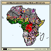
Map derived from the combined suitability of areas apt for commercial fish farming development and operation with areas with potential yield (crops/y) of African catfish for commercial farming. Areas with suitability for commercial fish farming were derived from the combined suitability of five land-quality factors important for fish farming development and operation; net annual water requirement for shallow ponds, soil and terrain suitability for the construction of fish ponds, potential livestock wastes and agriculture by-products as feed and fertilizer inputs, potential for farm-gate sales and potential market demand. Predictions of growth were based on water temperature, in turn predicted from air temperature and wind velocity data. Gridded values of mean monthly daily minimum and maximum temperatures were obtained from the Centre for Resource and Environmental Studies (CRES) at the Australian National University. Mean annual wind velocity was obtained from UNEP/DEIA/GRID-Geneva.
-
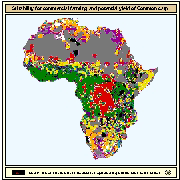
Map derived from the combined suitability of areas apt for commercial fish farming development and operation with areas with potential yield (crops/y) of Nile tilapia, African catfish and Common carp for small-scale farming. Areas with suitability for commercial fish farming were derived from the combined suitability of five land-quality factors important for fish farming development and operation; net annual water requirement for shallow ponds, soil and terrain suitability for the construction of fish ponds, potential livestock wastes and agriculture by-products as feed and fertilizer inputs, potential for farm-gate sales and potential market demand. Predictions of growth were based on water temperature, in turn predicted from air temperature and wind velocity data. Gridded values of mean monthly daily minimum and maximum temperatures were obtained from the Centre for Resource and Environmental Studies (CRES) at the Australian National University. Mean annual wind velocity was obtained from UNEP/DEIA/GRID-Geneva.
-
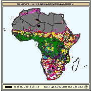
Map derived from the combined suitability of areas apt for small-scale fish farming development and operation with areas with potential yield (crops/y) of Common carp for small-scale farming. Areas with suitability for small-scale fish farming were derived from the combined suitability of four land-quality factors important for fish farming development and operation; net annual water requirement for shallow ponds, soil and terrain suitability for the construction of fish ponds, potential livestock wastes and agriculture by-products as feed and fertilizer inputs, and potential for farm-gate sales. Predictions of growth were based on water temperature, in turn predicted from air temperature and wind velocity data. Gridded values of mean monthly daily minimum and maximum temperatures were obtained from the Centre for Resource and Environmental Studies (CRES) at the Australian National University. Mean annual wind velocity was obtained from UNEP/DEIA/GRID-Geneva.
-
The crop water productivity (WPy) is computed by computing ratio of crop yield over water use for each crop type (cotton, paddy, redgram) over the Kharif season (July to December) 2019 for the Narayanapur Left Bank Canal (NLBC) in Karnataka state of India.
-
The crop yield is computed by applying harvest index to seasonal biomass for each crop type (cotton, paddy, redgram) over the Kharif season (July to December) 2019, for the Narayanapur Left Bank Canal (NLBC) in Karnataka state of India.