 FAO Map Catalog
Uruguay
Type of resources
Available actions
Topics
Keywords
Contact for the resource
Provided by
Formats
Representation types
Update frequencies
status
Scale
-
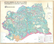
Aptitud general de uso de la tierra - Departamentos de Canelones y Montevideo; Description of the mapping units; (2 Sheets)
-
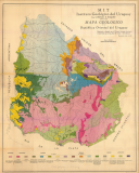
Mapa geologico de la Republica Oriental del Uruguay
-
This original full resolution land cover has been produced from visual interpretation of digitally enhanced LANDSAT 5TM images (30 m resolution), acquired mainly in the period 2007-2008. The land cover classes have been developed using the FAO/UNEP international standard LCCS classification system. This database can be analyzed in the GLCN software Advanced Database Gateway (ADG), which provides a user-friendly interface and advanced functionalities to breakdown the LCCS classes in their classifiers for further aggregations and analysis. Source: Programa Conjunto "Construyendo Capacidades para el desarrollo" 2007-2010 entre el Gobierno de la Républica Oriental del Uruguay y el Sistema de Nationes Unidas en Uruguay. Experiencia Piloto "Unidos en la Acción". RENARE/MGAP/DINAMA/DINOT/MVOTMA