 FAO Map Catalog
Tag_forestry
Type of resources
Available actions
Topics
Keywords
Contact for the resource
Provided by
Years
Formats
Representation types
Update frequencies
status
Scale
Resolution
-

The Congo forest cover change map 2000-2012 was created by the national forest services of Congo (CNIAFF) in collaboration with UN-REDD programme. It builds on 3 existing products that are combined to comply with the national forest definition (30% tree cover, 0.5 ha MMU). It is stratified into 3 forest types (Primary, Secondary, Primary/Swamp)
-
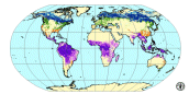
The Global Climate Risk Index 2020 analyses to what extent countries and regions have been affected by impacts of weather-related loss events (storms, floods, heat waves etc.). The most recent data available - for 2018 - were taken into account in this map. Source: The Climate Risk Index is based on data from Munich RE. Germanwatch
-
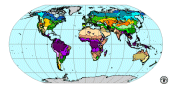
Along with the core information on state and changes in forests, FRA 2000 is reporting on various ecological aspects of forests. Forest resources information will be reported by ecological zone, which will contribute to understanding the implications of forest change on (ecosystem) biological diversity and carbon-cycling processes. The 2000 global ecological zone map has been developed, building upon the FRA 1990 experience for the tropics and extending the coverage to include the temperate and boreal forests. A globally consistent classification has been adopted, based on the Koppen-Trewartha climate system in combination with natural vegetation characteristics. A total of 19 global ecological zones have been defined and mapped, ranging from the evergreen tropical rainforest zone to the boreal tundra woodland zone. A main principle of delineating the global ecological zones involved the aggregation or matching of available regional ecological or potential vegetation maps into the global framework.
-
Data source: Bangladesh Forest Information System
-

Land cover of Bangladesh for the year 2015 based on SPOT 6m multispectral image segmentation and interpretation. Land cover classes are defined using Land Cover Classification System (LCCS) and are based on the National Land Representation system (NLRS).
-
The dataset represents the tree cover of Bangladesh. Trees and forests play a vital role in providing livelihood to the people living around forests. Forestry sector contributed to 3% of country’s GDP. However, GDP calculation does not take into consideration forestry contribution in term of energy, fodder, small timber and poles, thatching grass, medicinal herbs, and other forestry products. Data source: Bangladesh Forest Department
-
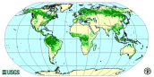
The forest cover map is the first comprehensive worldwide view of forests, using a consistent methodology and standard data. The map has a resolution of 1 km and is based on 1992-93 and 1995-96 AVHRR data. Four broad land cover categories are presented following FAO standard classification: closed forest, open/fragmented forest, other wooded land and other land. Due to the coarse source data, the map cannot be used to obtain reliable country forest cover statistics. The final map has been drafted through validation with information/maps based on higher resolution data, e.g. Landsat TM or SPOT images. An accuracy assessment will be carried out in year 2000 to determine the classification accuracy.
-
In 2015, the Bangladesh Forest Department, with technical support from FAO, and financial support from USAID, launched the project “strengthening National Forest Inventory and Satellite Land Monitoring in Support of REDD+ in Bangladesh”. Through this project, a robust and modern national forest monitoring system was developed, using the latest FAO tools such as Open Foris and LCCS to collect about 2000 permanent field inventory plots and over 6000 household surveys all over the country, integrating biophysical and socio-economic data and information.