 FAO Map Catalog
SRTM
Type of resources
Available actions
Topics
Keywords
Contact for the resource
Provided by
Years
Formats
Representation types
Update frequencies
status
Scale
Resolution
-
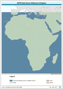
Polygonal seamless representation of SRTM Digital Elevation Model source reference. The SRC_PY shapefile data layer is comprised of 7536 derivative vector surface water bodies features derived based on 1:100 000 data originally from SRTM-SWBD. The layer provides nominal analytical/mapping at 1:125 000. Data processing 60% complete globally, with African and Arabian subsets 100% complete. Acronyms and Abbreviations: DEM - Digital Elevation Model; SRTM - Shuttle Radar Topography Mission.
-
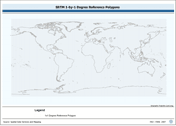
SRTM 1x1 degree tile reference layer with various encoding attributes. The 1X1_PY shapefile data layer is comprised of 64800 derivative vector surface water bodies features derived based on 1:100 000 data originally from SRTM-SWBD. The layer provides nominal analytical/mapping at 1:125 000. Data processing 60% complete globally, with African and Arabian subsets 100% complete. Acronyms and Abbreviations: SWBD - Surface water Body SRTM - Shuttle Radar Topography Mission;
-
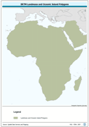
Seamless polygonal continental landmass and oceanic island mask data layer derived from SRTM-SWBD tiled database. The MASK_PY shapefile data layer is comprised of 4333 derivative vector surface water bodies features derived based on 1:100 000 data originally from SRTM-SWBD. The layer provides nominal analytical/mapping at 1:125 000. Data processing 60% complete globally, with African and Arabian subsets 100% complete. Acronyms and Abbreviations: SRTM - Shuttle Radar Topography Mission; SWBD - Surface water Body.
-

Linear representation of the nominal 30 metre coastlines; this is the highest resolution determinate currently available. The CSTLN_LN shapefile data layer is comprised of 11070 derivative vector surface water bodies features derived based on 1:100 000 data originally from SRTM-SWBD. The layer provides nominal analytical/mapping at 1:125 000. Data processing 60% complete globally, with African and Arabian subsets 100% complete. Acronyms and Abbreviations: SRTM - Shuttle Radar Topography Mission; SWBD - Surface water Body.
-
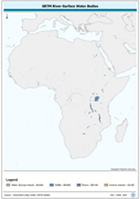
Seamless and robust derivative of SWB, Double-Lined River, and Inshore Island Features from SRTM-SWBD data tiles. The SWBD_PY shapefile data layer is comprised of 38840 derivative vector surface water bodies features derived based on 1:100 000 data originally from SRTM-SWBD. The layer provides nominal analytical/mapping at 1:125 000. Data processing 60% complete globally, with African and Arabian subsets 100% complete. Acronyms and Abbreviations: SWB or SWBD - Surface Water Body; SRTM - Shuttle Radar Topography Mission.
-
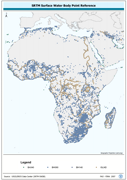
Centroid point locations of SWB, Double-Lined River and inshore island features. The SWBD_PT shapefile data layer is comprised of 38840 derivative vector surface water bodies features derived based on 1:100 000 data originally from SRTM-SWBD. The layer provides nominal analytical/mapping at 1:125 000. Data processing 60% complete globally, with African and Arabian subsets 100% complete. Acronyms and Abbreviations: SWB or SWBD - Surface Water Body; SRTM - Shuttle Radar Topography Mission.
-

Linear representation of SWB, Double-Lined River, and Inshore Island Features. The SWBD_LN shapefile data layer is comprised of 54741 derivative vector surface water bodies features derived based on 1:100 000 data originally from SRTM-SWBD. The layer provides nominal analytical/mapping at 1:125 000. Data processing 60% complete globally, with African and Arabian subsets 100% complete. Acronyms and Abbreviations: SWB or SWBD - Surface Water Body; SRTM - Shuttle Radar Topography Mission.
-

The altitude in (m) refers to median elevation at 5 arc-min while the slope class dataset refers to the median terrain slope class. Both datasets derived from a 3 arc-sec sub-grid of the Shuttle Radar Topography Mission (SRTM, http://www2.jpl.nasa.gov/srtm/). These datasets have been used to complement the survey data and included in the "Climate change predictions in Sub-Saharan Africa: impacts and adaptations (ClimAfrica)" project, Work Package 5 (WP5). More information on ClimAfrica project is provided in the Supplemental Information section of this metadata. This study in WP5 aimed to identify, locate and characterize groups that are vulnerable for climate change conditions in two country clusters; one in West Africa (Benin, Burkina Faso, Côte d'Ivoire, Ghana, and Togo) and one in East Africa (Sudan, South Sudan and Uganda). Data used for the study include the Demographic and Health Surveys (DHS) , the Multi Indicator Cluster Survey (MICS) and the Afrobarometer surveys for the socio-economic variables and grid level data on agro-ecological and climatic conditions.
-
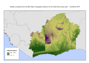
The altitude in (m) refers to median elevation at 5 arc-min while the slope class dataset refers to the median terrain slope class. Both datasets derived from a 3 arc-sec sub-grid of the Shuttle Radar Topography Mission (SRTM, http://www2.jpl.nasa.gov/srtm/). These datasets have been used to complement the survey data and included in the "Climate change predictions in Sub-Saharan Africa: impacts and adaptations (ClimAfrica)" project, Work Package 5 (WP5). More information on ClimAfrica project is provided in the Supplemental Information section of this metadata. This study in WP5 aimed to identify, locate and characterize groups that are vulnerable for climate change conditions in two country clusters; one in West Africa (Benin, Burkina Faso, Côte d'Ivoire, Ghana, and Togo) and one in East Africa (Sudan, South Sudan and Uganda). Data used for the study include the Demographic and Health Surveys (DHS) , the Multi Indicator Cluster Survey (MICS) and the Afrobarometer surveys for the socio-economic variables and grid level data on agro-ecological and climatic conditions.
-
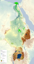
This map shows the Geographic Information System (GIS) ancillary information used to prepare thematic posters for the FAO-Nile Basin project. They are: -administrative units; -basin boundary; -boundary above water bodies; -country boundaries; canals&tunnels; -cities; -irrigated areas; -protected areas; -rivers; urban areas; -water bodies; -SRTM. Sources and information for each layer can be found in the "FAO Nile Information Products Synthesis Report" here available in the Distribution section of this metadata form.