 FAO Map Catalog
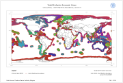
Oceans
Type of resources
Available actions
Topics
Keywords
Contact for the resource
Provided by
Years
Formats
Representation types
Update frequencies
status
Scale
-

Global Simplified Coastline (polygon version) extracted from the GAUL 2006 national level and simplified to produce a layer of continents and coastline suitable for thematic maps display purpose.
-
Polygon version of the linear data source UN_coast.shp file provided by the UN Cartographic Section. The original data is part of the 1:15 million-scale dataset which reflects, along with the 1:1 million-scale dataset, the cartography practice of the UN Cartographic Section for the representation of International Boundaries.
-

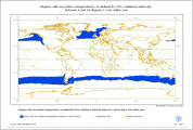
This dataset identifies all regions in which the full 95% confidence interval is wholly between 1.5 and 16 �C for all 12 months. The sea surface temperature data includes the mean sea surface temperature per month, the standard deviation and the number of observations used to calculate the mean. Based on these values, the 95% upper and lower confidence levels about the mean for each month have been generated.
-
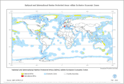
This polygon layer combines marine protected areas from the World Dataset of Protected Areas (UNEP-WCMW) and the Exclusive Economic Zones (VLIZ2009 - Flanders Marine Institute, Belgium) so that it reflects only marine portions of protected areas that have Exclusive Economic Zone attribute values. The dataset is also split into the following Geographic Zones: Arctic, Temperate, Intertemperate, Antarctic.
-

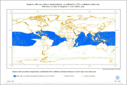
This dataset identifies all regions in which the full 95% confidence interval is wholly between 2.5 and 19 �C for all 12 months. The sea surface temperature data includes the mean sea surface temperature per month, the standard deviation and the number of observations used to calculate the mean. Based on these values, the 95% upper and lower confidence levels about the mean for each month have been generated.
-
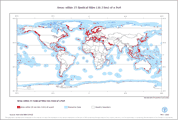
This polygon layer reflects marine areas within 25 nautical miles travel distance of ports, combined by country, and split by depth range, economic zone and geographic zone. The dataset is derived from port points (World Port Index - NGA-USA), bathymetry data (GEBCO_08) and exclusive economic zones (VLIZ2009 - Flanders Marine Institute, Belgium).
-
This dataset identifies all regions in which the full 95% confidence interval is between 4 and 18 �C for all 12 months. The sea surface temperature data includes the mean sea surface temperature per month, the standard deviation and the number of observations used to calculate the mean. Based on these values, the 95% upper and lower confidence levels about the mean for each month have been generated.
-
This dataset identifies all regions in which the full 95% confidence interval is between 22 and 32 �C for all 12 months. The sea surface temperature data includes the mean sea surface temperature per month, the standard deviation and the number of observations used to calculate the mean. Based on these values, the 95% upper and lower confidence levels about the mean for each month have been generated.
-

Continental shelf defined by 200 meters isobath, extracted from the General Bathymetric Chart of the Oceans (GEBCO) Digital Atlas - Centenary Edition.
-
This is a global dataset containing polygons of Exclusive Economic Zones. The layer, along with a polyline shapefile representing the world maritime boundaries and the extended continental Shelf of Australia, is included in VLIZ (2009) Maritime Boundaries Geodatabase - Version 5. The downloadable package (World EEZ v5 (86 MB) is available at http://www.vliz.be/vmdcdata/marbound/index.php Data Source: Flanders Marine Institute, Belgium. Data available online at http://www.vliz.be/vmdcdata/marbound/index.php Information on Methodology available at http://www.vliz.be/vmdcdata/marbound/methodology.php Data Contact: Nathalie De Hauwere: GIS Expert Francisco Hernandez: Manager Flanders Marine Datacentre Bart Vanhoorne: IT-specialist at http://www.vliz.be/vmdcdata/marbound/contact.php