 FAO Map Catalog
Fish farming
Type of resources
Available actions
Topics
Keywords
Contact for the resource
Provided by
Representation types
Update frequencies
status
Resolution
-
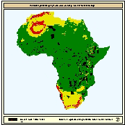
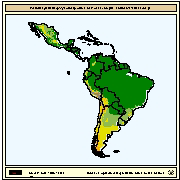
Spatial distribution of potential yield (crops/y) of Common carp for small-scale farming. Predictions of growth were based on water temperature, in turn predicted from air temperature and wind velocity data. Gridded values of mean monthly daily minimum and maximum air temperatures were obtained from the Centre for Resource and Environmental Studies (CRES) at the Australian National University. Mean annual wind velocity was obtained from UNEP/DEIA/GRID-Geneva.
-
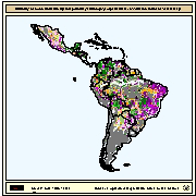
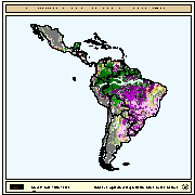
Map derived from the combined suitability of areas apt for commercial fish farming development and operation with areas with potential yield (crops/y) of pacu fed at 75% satiation and harvested at 600g. Suitable areas for commercial fish farming were derived from the combined suitability of five land-quality factors important for fish farming development and operation; net annual water loss from ponds through evaporation and seepage; soil and terrain suitability for ponds; potential for agriculture by-products and fertiliser inputs; potential for farm gate sales; and potential market demand. Yield estimations for pacu were based on water temperature which in turn were predicted from air temperature. Mean maximum and minimum monthly air temperatures grids were provide by FAO's Agrometeorology group. In order to explore a range of commercial aquaculture possibilities by the use of the growth model, simulations were conducted for pacu, assuming two different feeding levels and two harvesting weights (600 and 1,000 g). Feed application rates corresponding to 50% and 75% satiation were assumed to represent commercial aquaculture operations with low and high feeding rates, respectively.
-
Spatial distribution of potential yield (crops/y) of carp fed at 75% satiation and harvested at 600g. Yield estimations for carp were based on water temperature which in turn were predicted from air temperature. Mean maximum and minimum monthly air temperatures grids were provide by FAO's Agrometeorology group. In order to explore a range of commercial aquaculture possibilities by the use of the growth model, simulations were conducted for carp, assuming two different feeding levels and two harvesting weights (600 and 1,500 g). Feed application rates corresponding to 50% and 75% satiation were assumed to represent commercial aquaculture operations with low and high feeding rates, respectively.
-
Spatial distribution of potential yield (crops/y) of tambaqui fed at 75% satiation and harvested at 600g. Yield estimations for tambaqui were based on water temperature which in turn were predicted from air temperature. Mean maximum and minimum monthly air temperatures grids were provide by FAO's Agrometeorology group. In order to explore a range of commercial aquaculture possibilities by the use of the growth model, simulations were conducted for tambaqui, assuming two different feeding levels and two harvesting weights (600 and 1000 g). Feed application rates corresponding to 50% and 75% satiation were assumed to represent commercial aquaculture operations with low and high feeding rates, respectively.
-
Map derived from the combined suitability of areas apt for commercial fish farming development and operation with areas with potential yield (crops/y) of carp fed at 75% satiation and harvested at 600g. Suitable areas for commercial fish farming were derived from the combined suitability of five land-quality factors important for fish farming development and operation; net annual water loss from ponds through evaporation and seepage; soil and terrain suitability for ponds; potential for agriculture by-products and fertiliser inputs; potential for farm gate sales; and potential market demand. Yield estimations for carp were based on water temperature which in turn were predicted from air temperature. Mean maximum and minimum monthly air temperatures grids were provide by FAO's Agrometeorology group. In order to explore a range of commercial aquaculture possibilities by the use of the growth model, simulations were conducted for carp, assuming two different feeding levels and two harvesting weights (600 and 1,000 g). Feed application rates corresponding to 50% and 75% satiation were assumed to represent commercial aquaculture operations with low and high feeding rates, respectively.
-
Map derived from the combined suitability of areas apt for commercial fish farming development and operation with areas with potential yield (crops/y) of Nile tilapia fed at 75% satiation and harvested at 600g. Suitable areas for commercial fish farming were derived from the combined suitability of five land-quality factors important for fish farming development and operation; net annual water loss from ponds through evaporation and seepage; soil and terrain suitability for ponds; potential for agriculture by-products and fertiliser inputs; potential for farm gate sales; and potential market demand. Yield estimations for Nile tilapia were based on water temperature which in turn were predicted from air temperature. Mean maximum and minimum monthly air temperatures grids were provide by FAO's Agrometeorology group. In order to explore a range of commercial aquaculture possibilities by the use of the growth model, simulations were conducted for Nile tilapia, assuming two different feeding levels and two harvesting weights (600 and 1,000 g). Feed application rates corresponding to 50% and 75% satiation were assumed to represent commercial aquaculture operations with low and high feeding rates, respectively.
-
Spatial distribution of potential yield (crops/y) of carp with a CFB of 0.075 kg/m3 and harvested at 350g. Yield estimations for carp were based on water temperature which in turn were predicted from air temperature. Mean maximum and minimum monthly air temperatures grids were provide by FAO's Agrometeorology group. In order to explore a range of small-scale aquaculture possibilities by the use of the growth model, simulations were conducted for carp, assuming a harvesting weight of 350g. Natural food availability was modelled as a function of fish biomass and approach that requires definition of the critical standing crop (in kg/ha) or critical fish biomass (CFB; in kg/m3). For carp, ponds that are not heavily fertilized or fed, a CFB of about 0.075 kg/m3 (equivalent to a fish biomass of 750 kg/ha) was considered reasonable.
-
Map derived from the combined suitability of areas apt for small-scale fish farming development and operation with areas with potential yield (crops/y) of Nile tilapia with a CFB of 0.075 kg/m3 and harvested at 150g. Suitable areas for small-scale fish farming were derived from the combined suitability of five land-quality factors important for fish farming development and operation; net annual water loss from ponds through evaporation and seepage; soil and terrain suitability for ponds; potential for agriculture by-products and fertiliser inputs; potential for farm gate sales; and potential market demand. Yield estimations for Nile tilapia were based on water temperature which in turn were predicted from air temperature. Mean maximum and minimum monthly air temperatures grids were provide by FAO's Agrometeorology group. In order to explore a range of small-scale aquaculture possibilities by the use of the growth model, simulations were conducted for Nile tilapia, assuming a harvesting weight of 150g. Natural food availability was modelled as a function of fish biomass and approach that requires definition of the critical standing crop (in kg/ha) or critical fish biomass (CFB; in kg/m3). For tilapia, ponds that are not heavily fertilized or fed, a CFB of about 0.075 kg/m3 (equivalent to a fish biomass of 750 kg/ha) was considered reasonable.
-
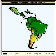
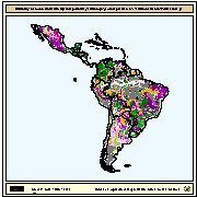
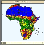
Areas with suitability for commercial fish farming development and operation. Map derived from the combined suitability of five land-quality factors important for fish farming development and operation; net annual water requirement for shallow ponds, soil and terrain suitability for the construction of fish ponds, potential livestock wastes and agriculture by-products as feed and fertilizer inputs, potential for farm-gate sales and potential market demand.
-
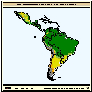
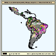
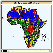
Areas with suitability for small-scale fish farming development and operation. Map derived from the combined suitability of four land-quality factors important for fish farming development and operation; net annual water requirement for shallow ponds, soil and terrain suitability for the construction of fish ponds, potential livestock wastes and agriculture by-products as feed and fertilizer inputs, and potential for farm-gate sales.