 FAO Map Catalog
Burundi
Type of resources
Available actions
Topics
Keywords
Contact for the resource
Provided by
Years
Formats
Representation types
Update frequencies
status
Scale
Resolution
-

Coverage: Rwanda and Burundi
-

Include: Regions naturelles; isohyetes; isothermes; geologie (inset maps) (1500000) - Lithologie, vegetation (inset maps) (1500000); Legend of the map
-

Include: Bukirasazi (SA-35-XXIV-4b); Topographic map
-
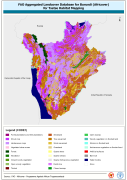
This dataset is an aggregated version of the original national Africover landcover multipurpose database. A 26-class legend is used to aggregate the classes present in the original full resolution, multipurpose landcover database. A single legend is applicable to the eight trypanosomiasis-affected countries mapped during Africover project (Burundi, Democratic Republic of the Congo, Kenya, Rwanda, Somalia, Sudan, Uganda and United Republic of Tanzania).
-
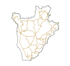
The full resolution dataset of roads have been produced from visual interpretation of digitally enhanced LANDSAT TM images (Bands 4,3,2) acquired mainly in the year 1999.
-
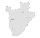
The full resolution dataset of towns was developed from data from the National Imagery and Mapping Agency (NIMA).
-

Include: Carte de la végétation (Michel, G.) (200 000)
-

Include: Carte detaillée des sols Carte detaillée de la végétation
-
Carte des sols et de la végétation du Congo belge et du Ruanda-Urundi. 5. Mosso (Urundi) - (Kininya)

Include: Sols, Kininya (Sys, C.) (Feuille 2)
-

Include: Carte d'utilisation des sols (Sys, C.) (200 000).