 FAO Map Catalog
Africa
Type of resources
Available actions
Topics
Keywords
Contact for the resource
Provided by
Years
Formats
Representation types
Update frequencies
status
Scale
Resolution
-
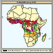
Areas with potential for subsistence fish farming under three temperature regimes providing for one crop/year (1C) with fair to good growth (FGG), two crops/year with fair growth (FG) and with good growth (GG) in combination with four land-quality factors important for fish farming development and operation; water availability, engineering capability, and economic considerations ranging from all suitable to one suitable and two optimum (S-NO), or all optimum (all 0).
-
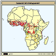
Areas with potential for commercial fish farming under three temperature regimes providing for one crop/year (1C) with fair to good growth (FGG), two crops/year with fair growth (FG) and with good growth (GG) in combination with four land-quality factors important for fish farming development and operation; water availability, engineering capability, and economic considerations ranging from all suitable to one suitable and two optimum (S-NO), or all optimum (all 0).
-
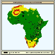
Spatial distribution of potential yield (crops/y) of Common carp for small-scale farming. Predictions of growth were based on water temperature, in turn predicted from air temperature and wind velocity data. Gridded values of mean monthly daily minimum and maximum air temperatures were obtained from the Centre for Resource and Environmental Studies (CRES) at the Australian National University. Mean annual wind velocity was obtained from UNEP/DEIA/GRID-Geneva.
-
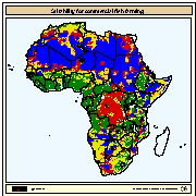
Areas with suitability for commercial fish farming development and operation. Map derived from the combined suitability of five land-quality factors important for fish farming development and operation; net annual water requirement for shallow ponds, soil and terrain suitability for the construction of fish ponds, potential livestock wastes and agriculture by-products as feed and fertilizer inputs, potential for farm-gate sales and potential market demand.
-
Areas with suitability for small-scale fish farming development and operation. Map derived from the combined suitability of four land-quality factors important for fish farming development and operation; net annual water requirement for shallow ponds, soil and terrain suitability for the construction of fish ponds, potential livestock wastes and agriculture by-products as feed and fertilizer inputs, and potential for farm-gate sales.
-
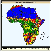
Land use statistics
-
This dataset represents the third-level administrative unit 'freguesias' of Cape Verde. The dataset was originally produced by the Instituto Nacional de Gestão do Território (INGT), Cape Verde from 2010 administrative division. The reference scale for this Geospatial data is equivalent to 1:5,000 scale. The data was sourced from FAOCV in February 2022, feature topology/geometry was corrected, and international borders validated against the United Nations official borders (United Nations Geospatial Information Section - UN-Map 2018). The dataset is part of FAO's Hand-in-Hand (HiH) second administrative level boundaries 2022 dataset series, published on the HiH Geospatial Platform for thematic mapping, integration of geospatially enabled statistics, zonal statistics extraction, and used for HiH initiative geospatial analysis (GIS-MCDA, suitability/location analysis, agricultural typologies).
-
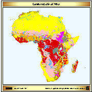
Simplified version of the FAO/UNESCO soil map of the world, containing only 8 major soil classes. The map has been used to do the back cover of the publication GIS in FAO (FAO, Feb 89)
-
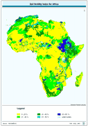
Soil fertility index for Africa derived from the FAO/UNESCO Digital Soil Map of the World interpreted in terms of soil fertility.
-
This dataset represents the second-level administrative unit 'Communes' of Burundi. The dataset was uploaded by the Institut Géographique du Burundi in September 2021 to Second Administrative Level Boundaries (SALB) Program of United Nations. The reference scale for this Geospatial data is equivalent to 1:1,000,000 scale, or larger scale. Data was downloaded from UN-SALB site in November 2022, feature topology/geometry was corrected, international borders validated against the United Nations official borders (United Nations Geospatial Information Section - UN-Map 2018). The dataset is part of FAO's Hand-in-Hand (HiH) second administrative level boundaries 2022 dataset series, published on the HiH Geospatial Platform for thematic mapping, integration of geospatially enabled statistics, zonal statistics extraction, and used for HiH initiative geospatial analysis (GIS-MCDA, suitability/location analysis, agricultural typologies).