 FAO Map Catalog
AQUAMAPS_basins
Type of resources
Available actions
Topics
Keywords
Contact for the resource
Provided by
Years
Formats
Representation types
Update frequencies
status
Scale
-

This dataset divides the Near East in major hydrological basins and their sub-basins according to its hydrological characteristics. It was obtained by delineating drainage basin boundaries from hydrologically corrected elevation data (WWF HydroSHEDS and Hydro1K). The dataset consists of the following information:- numerical code and name of the major basin (MAJ_BAS and MAJ_NAME); - area of the major basin in square km (MAJ_AREA); - numerical code and name of the sub-basin (SUB_BAS and SUB_NAME); - area of the sub-basin in square km (SUB_AREA); - numerical code of the sub-basin towards which the sub-basin flows (TO_SUBBAS) (the codes -888 and -999 have been assigned respectively to internal sub-basins and to sub-basins draining into the sea)
-

This dataset divides the Australian continent in major hydrological basins and their sub-basins according to its hydrological characteristics. It was obtained by delineating drainage basin boundaries from hydrologically corrected elevation data (WWF HydroSHEDS and Hydro1K). The dataset consists of the following information:- numerical code and name of the major basin (MAJ_BAS and MAJ_NAME); - area of the major basin in square km (MAJ_AREA); - numerical code and name of the sub-basin (SUB_BAS and SUB_NAME); - area of the sub-basin in square km (SUB_AREA); - numerical code of the sub-basin towards which the sub-basin flows (TO_SUBBAS) (the codes -888 and -999 have been assigned respectively to internal sub-basins and to sub-basins draining into the sea)
-
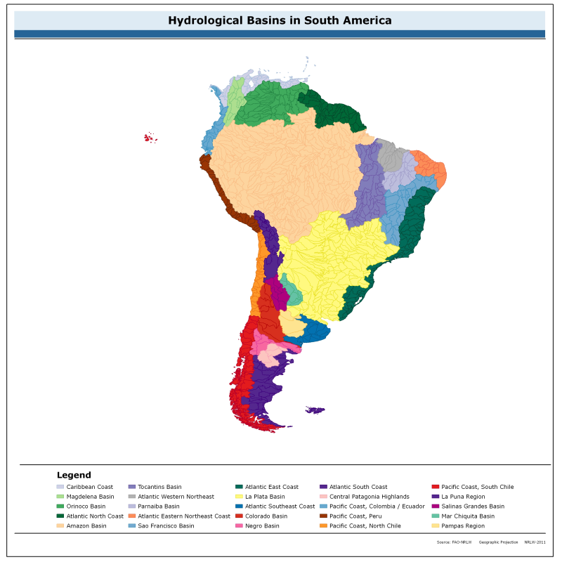
This dataset divides the South American continent in major hydrological basins and their sub-basins according to its hydrological characteristics. It was obtained by delineating drainage basin boundaries from hydrologically corrected elevation data (WWF HydroSHEDS and Hydro1K). The dataset consists of the following information:- numerical code and name of the major basin (MAJ_BAS and MAJ_NAME); - area of the major basin in square km (MAJ_AREA); - numerical code and name of the sub-basin (SUB_BAS and SUB_NAME); - area of the sub-basin in square km (SUB_AREA); - numerical code of the sub-basin towards which the sub-basin flows (TO_SUBBAS) (the codes -888 and -999 have been assigned respectively to internal sub-basins and to sub-basins draining into the sea)
-

This dataset divides the North American continent in major hydrological basins and their sub-basins according to its hydrological characteristics. It was obtained by delineating drainage basin boundaries from hydrologically corrected elevation data (WWF HydroSHEDS and Hydro1K). The dataset consists of the following information:- numerical code and name of the major basin (MAJ_BAS and MAJ_NAME); - area of the major basin in square km (MAJ_AREA); - numerical code and name of the sub-basin (SUB_BAS and SUB_NAME); - area of the sub-basin in square km (SUB_AREA); - numerical code of the sub-basin towards which the sub-basin flows (TO_SUBBAS) (the codes -888 and -999 have been assigned respectively to internal sub-basins and to sub-basins draining into the sea)
-
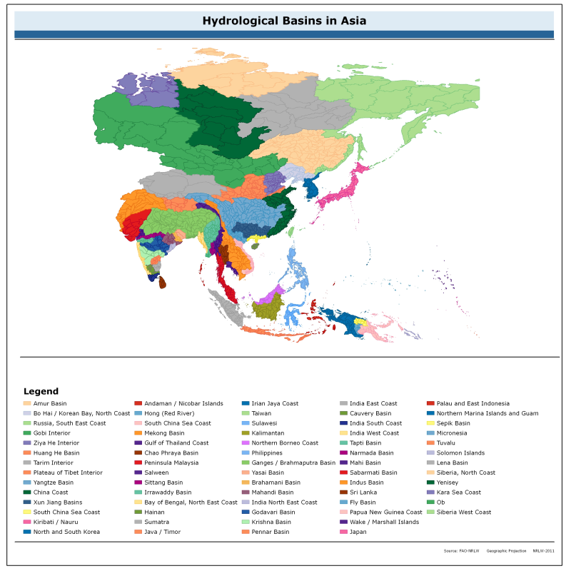
This dataset divides the Asian continent in major hydrological basins and their sub-basins according to its hydrological characteristics. It was obtained by delineating drainage basin boundaries from hydrologically corrected elevation data (WWF HydroSHEDS and Hydro1K). The dataset consists of the following information:- numerical code and name of the major basin (MAJ_BAS and MAJ_NAME); - area of the major basin in square km (MAJ_AREA); - numerical code and name of the sub-basin (SUB_BAS and SUB_NAME); - area of the sub-basin in square km (SUB_AREA); - numerical code of the sub-basin towards which the sub-basin flows (TO_SUBBAS) (the codes -888 and -999 have been assigned respectively to internal sub-basins and to sub-basins draining into the sea)
-

This dataset divides the Central American continent in major hydrological basins and their sub-basins.according to its hydrological characteristics. It was obtained by delineating drainage basin boundaries from hydrologically corrected elevation data (WWF HydroSHEDS and Hydro1K). The dataset consists of the following information:- numerical code and name of the major basin (MAJ_BAS and MAJ_NAME); - area of the major basin in square km (MAJ_AREA); - numerical code and name of the sub-basin (SUB_BAS and SUB_NAME); - area of the sub-basin in square km (SUB_AREA); - numerical code of the sub-basin towards which the sub-basin flows (TO_SUBBAS) (the codes -888 and -999 have been assigned respectively to internal sub-basins and to sub-basins draining into the sea)
-
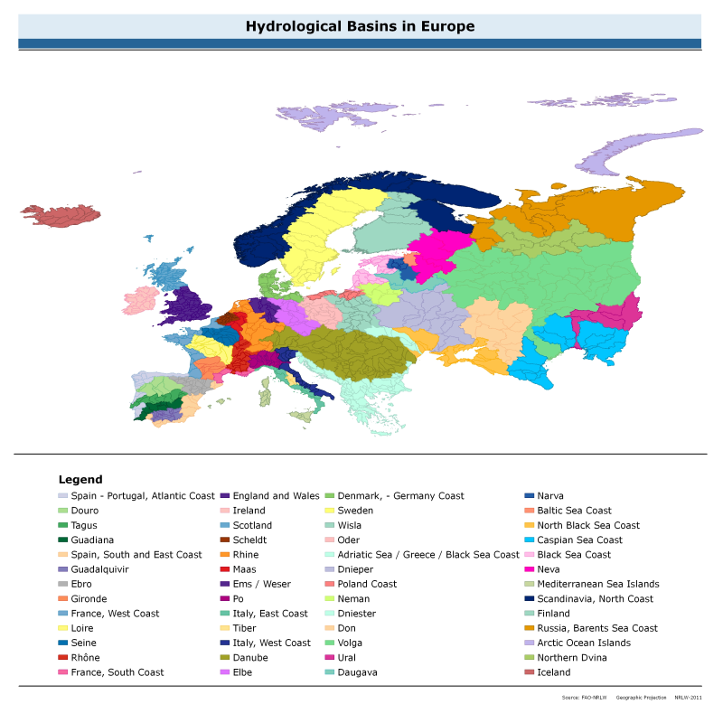
This dataset divides the European continent in major hydrological basins and their sub-basins according to its hydrological characteristics. It was obtained by delineating drainage basin boundaries from hydrologically corrected elevation data (WWF HydroSHEDS and Hydro1K). The dataset consists of the following information:- numerical code and name of the major basin (MAJ_BAS and MAJ_NAME); - area of the major basin in square km (MAJ_AREA); - numerical code and name of the sub-basin (SUB_BAS and SUB_NAME); - area of the sub-basin in square km (SUB_AREA); - numerical code of the sub-basin towards which the sub-basin flows (TO_SUBBAS) (the codes -888 and -999 have been assigned respectively to internal sub-basins and to sub-basins draining into the sea)
-
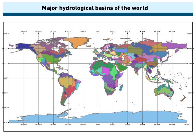
This dataset was obtained by delineating drainage basin boundaries from hydrologically corrected elevation data (HydroSHEDS and Hydro1K). Input data resolution is 15 arc-seconds between 60 N and 60 S latitude (based on SRTM), and 30 arc-seconds for higher latitudes (based on GTOPO30). The dataset consists of the following information: numerical code (MAJ_BAS), name (MAJ_NAME) and area (MAJ_AREA) of the major basin in square km.
-
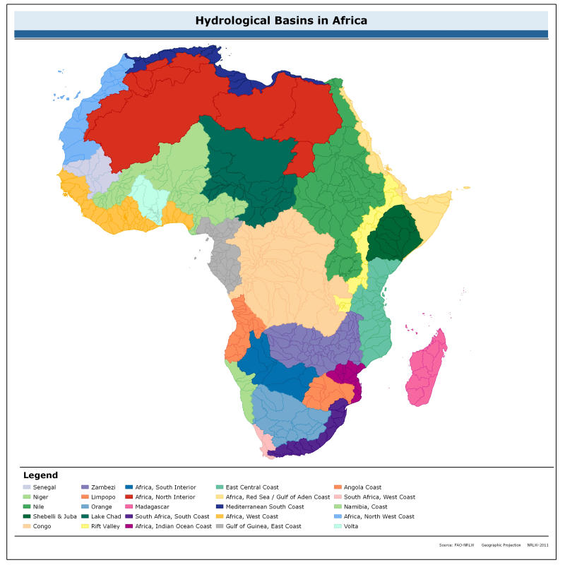
This dataset divides the African continent in major hydrological basins and their sub-basins according to its hydrological characteristics. It was obtained by delineating drainage basin boundaries from hydrologically corrected elevation data (WWF HydroSHEDS and Hydro1K). The dataset consists of the following information:- numerical code and name of the major basin (MAJ_BAS and MAJ_NAME); - area of the major basin in square km (MAJ_AREA); - numerical code and name of the sub-basin (SUB_BAS and SUB_NAME); - area of the sub-basin in square km (SUB_AREA); - numerical code of the sub-basin towards which the sub-basin flows (TO_SUBBAS) (the codes -888 and -999 have been assigned respectively to internal sub-basins and to sub-basins draining into the sea)