 FAO Map Catalog
5000000
Type of resources
Available actions
Topics
Keywords
Contact for the resource
Provided by
Years
Formats
Representation types
Update frequencies
status
Scale
-
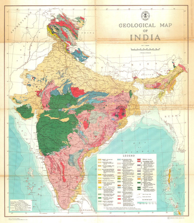
Geological map of India
-
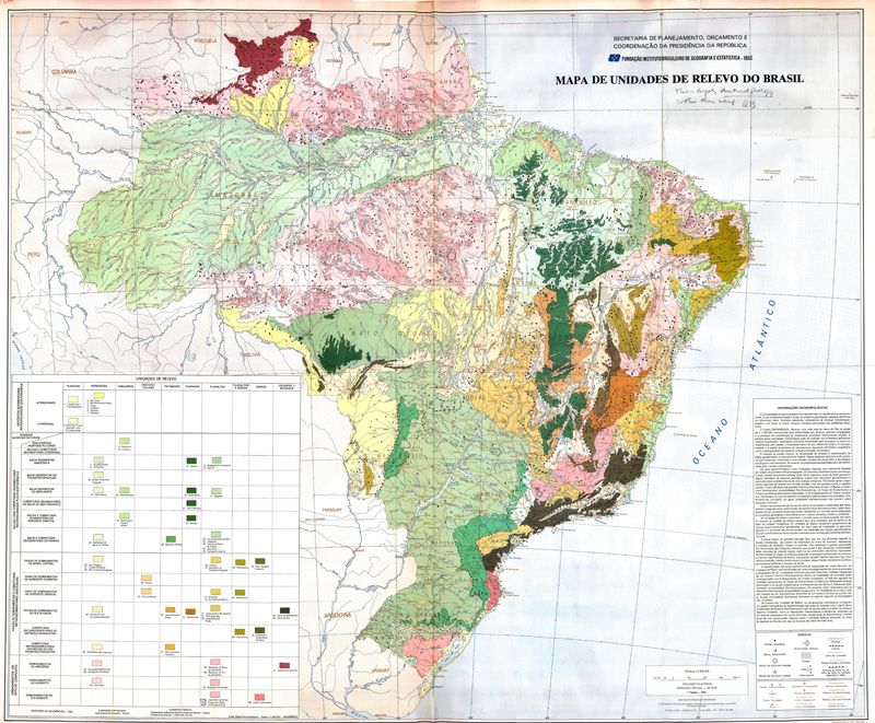
Mapa de Unidades de Relevo do Brasil (1a edicao) (Geological Map)
-

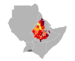
Average altitude in Djibouti, Eritrea, Ethiopia, Kenya, Somalia, Sudan and Uganda.
-
Teff yield in Djibouti, Eritrea, Ethiopia, Kenya, Somalia, Sudan and Uganda. Map presents reference yield estimated through data collection and agricultural statistics.
-
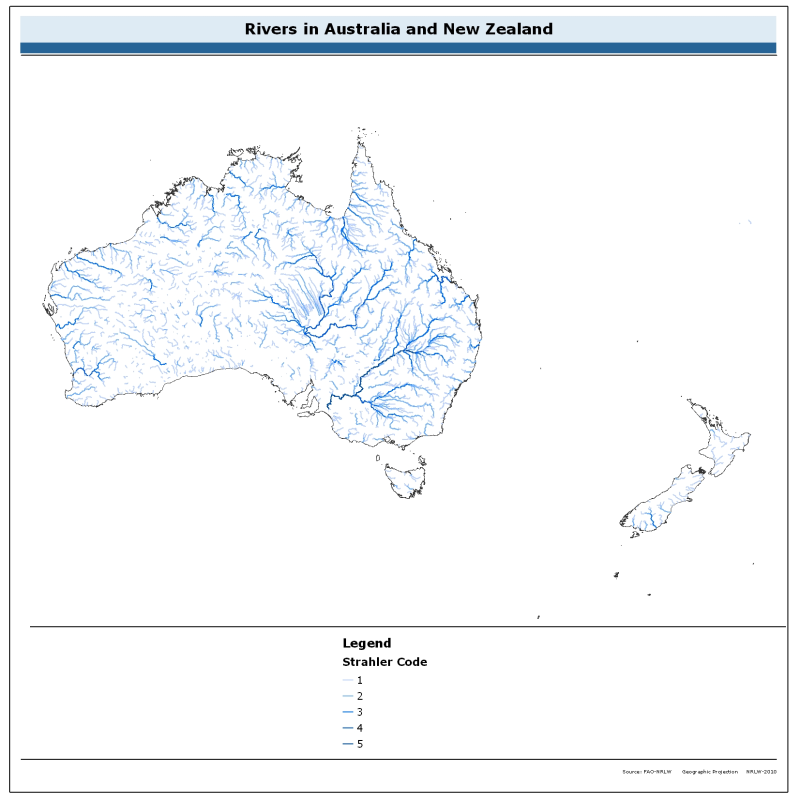
The rivers of Australia and New Zealand dataset is derived from the World Wildlife Fund's (WWF) HydroSHEDS drainage direction layer and a stream network layer. The source of the drainage direction layer was the 15-second Digital Elevation Model (DEM) from NASA's Shuttle Radar Topographic Mission (SRTM). The raster stream network was determined by using the HydroSHEDS flow accumulation grid, with a threshold of about 1000 km² upstream area. The stream network dataset consists of the following information: the origin node of each arc in the network (FROM_NODE), the destination of each arc in the network (TO_NODE), the Strahler stream order of each arc in the network (STRAHLER), numerical code and name of the major basin that the arc falls within (MAJ_BAS and MAJ_NAME); - area of the major basin in square km that the arc falls within (MAJ_AREA); - numerical code and name of the sub-basin that the arc falls within (SUB_BAS and SUB_NAME); - area of the sub-basin in square km that the arc falls within (SUB_AREA); - numerical code of the sub-basin towards which the sub-basin flows that the arc falls within (TO_SUBBAS) (the codes -888 and -999 have been assigned respectively to internal sub-basins and to sub-basins draining into the sea). The attributes table now includes a field named "Regime" with tentative classification of perennial ("P") and intermittent ("I") streams.
-
Average terrain-slope characteristics in Djibouti, Eritrea, Ethiopia, Kenya, Somalia, Sudan and Uganda.
-
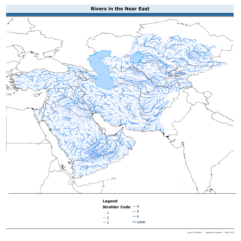
The rivers of the Near East dataset is derived from the World Wildlife Fund's (WWF) HydroSHEDS drainage direction layer and a stream network layer. The source of the drainage direction layer was the 15-second Digital Elevation Model (DEM) from NASA's Shuttle Radar Topographic Mission (SRTM). The raster stream network was determined by using the HydroSHEDS flow accumulation grid, with a threshold of about 1000 km² upstream area. The stream network dataset consists of the following information: the origin node of each arc in the network (FROM_NODE), the destination of each arc in the network (TO_NODE), the Strahler stream order of each arc in the network (STRAHLER), numerical code and name of the major basin that the arc falls within (MAJ_BAS and MAJ_NAME); - area of the major basin in square km that the arc falls within (MAJ_AREA); - numerical code and name of the sub-basin that the arc falls within (SUB_BAS and SUB_NAME); - area of the sub-basin in square km that the arc falls within (SUB_AREA); - numerical code of the sub-basin towards which the sub-basin flows that the arc falls within (TO_SUBBAS) (the codes -888 and -999 have been assigned respectively to internal sub-basins and to sub-basins draining into the sea). The attributes table now includes a field named "Regime" with tentative classification of perennial ("P") and intermittent ("I") streams.
-
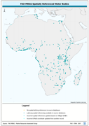
Spatially World Lake features which could be cross-referenced to VMap0 - SWB features. The AF_WL_PT shapefile data layer is comprised of 499 derivative tabular | point limnological, world lakes and rivers features derived based on 1:5 000 000 data originally from FAO. The layer provides nominal analytical/mapping at 1:5 000 000. Data processing 60% complete globally, with African and Arabian subsets 100% complete. Acronyms and Abbreviations: VMap0 - Vector Map for Level 0; SWB - Surface Water Body.
-
2015 Farming Systems for Sub-Saharan Africa region at the continental level to capture current spatial extent of systems and provide a basis for updated analysis, trends, issues and strategic priorities for each system. In 2000 as part of the Joint FAO-World Bank Farming Systems and Poverty Study (Dixon et al 2001) separate broad-scale farming systems were identified for the six World Bank Development Regions of the world. The current dataset is an update of the 2000 study and identifies Farming Systems for Africa at the continental level to capture current spatial extent of systems and provide a basis for updated analysis, trends, issues and strategic priorities for each system. Within this context delineating major farming systems provides a framework to guide development and targeting of strategic agricultural policies and interventions to reduce poverty and promote the adoption of more sustainable land management practices. In the 2015 study Systems were identified using an iterative process and a series of classifiers/informants including: available natural resources ( water, land, soils, elevation, length of growing period); Population (agriculture, rural, urban and total); Copping and pasture extent; the dominant pattern of farming activities and household livelihoods; access to markets and trends; nutrition, and estimated farm size Perhaps John which were augmented with expert input. A multidisciplinary team of experts were associated with each farming system assisting in the identification and characterisation process along with the documentation of issues such are emergent properties, drivers of change and trends, and priorities for each system. The current work updates and expands on the analysis of Sub-Saharan Africa Farming Systems in Dixon 2001 study. Many farming systems exhibit a strong geographical pattern reflecting a mix of factors such as climate, soil and markets. At the continental level broadly similar farming systems share recognizable livelihood patterns and similar development pathways, infrastructure and policy needs.
-
Length of growing period in Djibouti, Eritrea, Ethiopia, Kenya, Somalia, Sudan and Uganda.