 FAO Map Catalog
200000
Type of resources
Available actions
Topics
Keywords
Contact for the resource
Provided by
Years
Formats
Representation types
Update frequencies
status
Scale
-
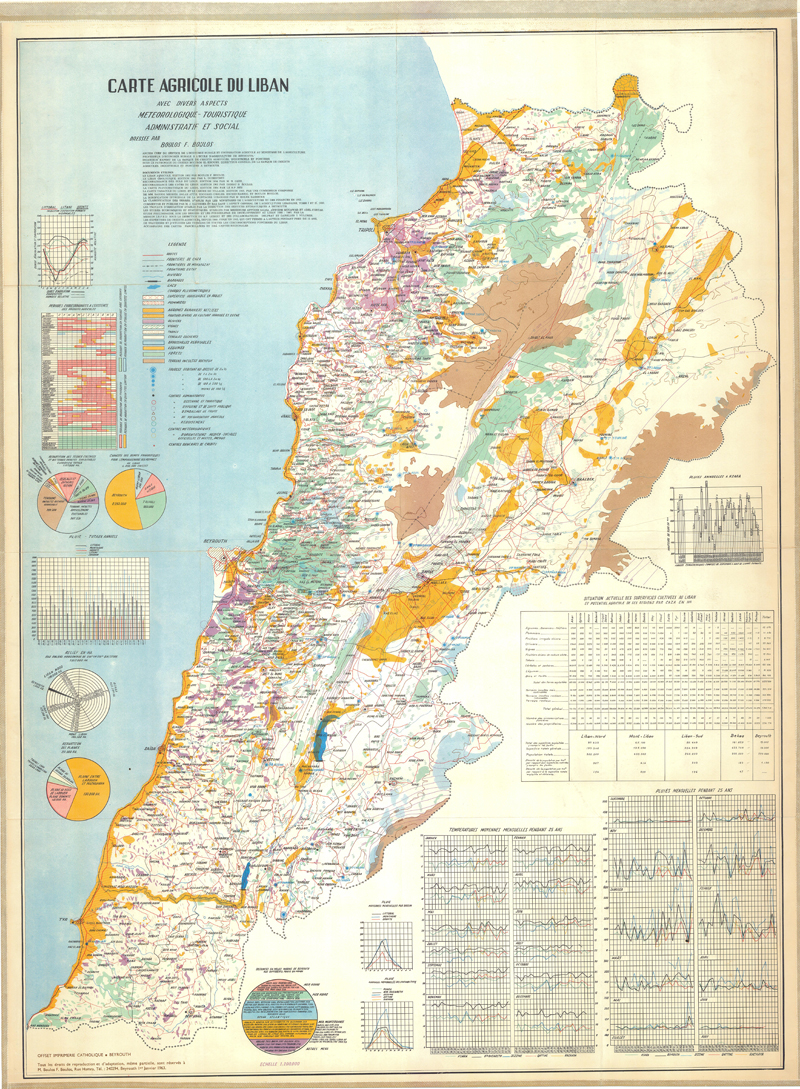
Carte agricole du Liban avec divers aspects météorologique-touristique-administratif et social (3ème édition)
-

This dataset is a thematic reaggregated version of the original national Africover landcover multipurpose database. It contains all natural vegetation with a woody component. The original full resolution land cover has been produced from visual interpretation of digitally enhanced LANDSAT TM images (Bands 4,3,2) acquired mainly in the year 1997 (see the "Multipurpose Landcover Database" metadata for more details). This dataset is intended for free public access. Thematic aggregation is the way that the end user customizes the Africover database to fulfil his/her specific requirements. The Africover database gives equal level of detail to Agriculture as well as Natural vegetation or Bare Areas etc. Generally a single user does not need this level of detail for each class type; therefore he/she will enhance the information of one land cover type and will generalize or erase the information related to other land cover aspects. The most powerful way to conduct an aggregation exercise is to use the classifiers as basic elements of the exercise. This gives the user the maximum flexibility on the use of data. The shape main attributes correspond to the following fields: -ID -HECTARES -WOODY_ID -WOODY_DESC You can download a zip archive containing: -the tz-woody-agg (.shp) -the Tanzania Classifiers Used (.pdf) -the Tanzania legend (.pdf and .xls) -the Tanzania Legend - LCCS Import file (.xls) -the LCCSglossary_tanzania (.pdf) -the thematic-aggregation-procedure (.pdf) -the thematic-aggregation-annex1 (.pdf) -the thematic-aggregation-annex2 (.pdf) -the Userlabel Definitions (.pdf)
-

Coverage: Bayanga (Soil Map)
-

Include: Légende de la qualité des parcours (feuille II)
-

This vector layer (line) – reference scale 1/200 000 – is a drainage network model of the CORB-Contributing area. In the attributes table, each drainage line is linked to the micro catchment in which it resides. The creation of this layer was achieved by filtering the Drainage Network model with visual analyses of topographic maps and DTM model. This dataset is part of the GIS Database for the Environment Protection and Sustainable Management of the Okavango River Basin project (EPSMO). Detailed information on the database can be found in the “GIS Database for the EPSMO Project†document produced by Luis Veríssimo (FAO consultant) in July 2009, and here available for download.
-
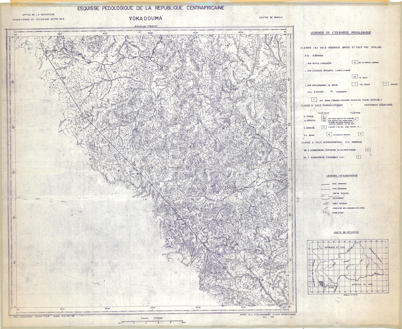
Coverage: Yokadouma (Soil Map)
-
This dataset is a thematic reaggregated version of the original national Africover landcover multipurpose database. It contains all natural vegetation with a woody component. The original full resolution land cover has been produced from visual interpretation of digitally enhanced LANDSAT TM images (Bands 4,3,2) acquired mainly in the period 1995-1998 (see the "Multipurpose Landcover Database" metadata for more details). This dataset is intended for free public access. Thematic aggregation is the way that the end user customizes the Africover database to fulfil his/her specific requirements. The Africover database gives equal level of detail to Agriculture as well as Natural vegetation or Bare Areas etc. Generally a single user does not need this level of detail for each class type; therefore he/she will enhance the information of one land cover type and will generalize or erase the information related to other land cover aspects. The most powerful way to conduct an aggregation exercise is to use the classifiers as basic elements of the exercise. This gives the user the maximum flexibility on the use of data. The shape main attributes correspond to the following fields: -ID -HECTARES -WOODY_ID -WOODY_DESC You can download a zip archive containing: -the sm-woody-agg (.shp) -the Somalia Classifiers Used (.pdf) -the Somalia legend (.pdf and .xls) -the Somalia Legend - LCCS Import file (.xls) -the LCCSglossary_somalia(.pdf) -the thematic-aggregation-procedure (.pdf) -the thematic-aggregation-annex1 (.pdf) -the thematic-aggregation-annex2 (.pdf) -the Userlabel Definitions (.pdf)
-

Carte pédologique du bassin du Moyen Logone (Sheet East and West)
-
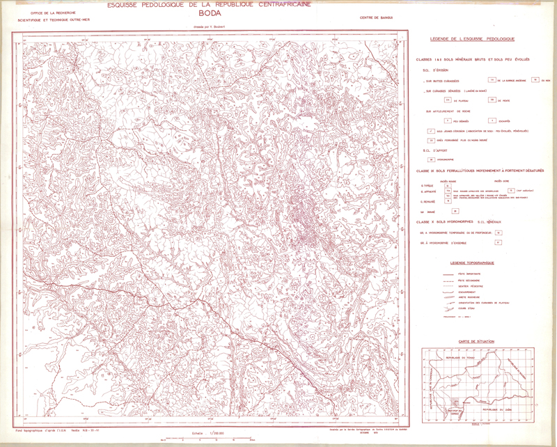
Coverage: Boda (Soil Map)
-
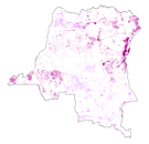
This dataset is a thematic reaggregated version of the original national Africover landcover multipurpose database. It contains all cultivated land. The original full resolution land cover has been produced from visual interpretation of digitally enhanced LANDSAT TM images (Bands 4,3,2) acquired mainly in the period 2000-2001 (see the "Multipurpose Landcover Database" metadata for more details). This dataset is intended for free public access. Thematic aggregation is the way that the end user customizes the Africover database to fulfil his/her specific requirements. The Africover database gives equal level of detail to Agriculture as well as Natural vegetation or Bare Areas etc. Generally a single user does not need this level of detail for each class type; therefore he/she will enhance the information of one land cover type and will generalize or erase the information related to other land cover aspects. The most powerful way to conduct an aggregation exercise is to use the classifiers as basic elements of the exercise. This gives the user the maximum flexibility on the use of data. The shape main attributes correspond to the following fields: -ID -HECTARES -CULT_ID -CULT_DESC You can download a zip archive containing: -the drc-cult-agg (.shp) -the DR Congo Classifiers Used (.pdf) -the DR Congo legend (.pdf and .xls) -the DR Congo Legend - LCCS Import file (.xls) -the LCCSglossary_drcongo (.pdf) -the thematic-aggregation-procedure (.pdf) -the thematic-aggregation-annex1 (.pdf) -the thematic-aggregation-annex2 (.pdf) -the Userlabel Definitions (.pdf)