 FAO Map Catalog
Inva
Type of resources
Available actions
Topics
Keywords
Contact for the resource
Provided by
Years
Representation types
Update frequencies
status
Scale
-
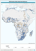
Centroid point locations of SWB, Double-Lined River and inshore island features. The SWBD_PT shapefile data layer is comprised of 38840 derivative vector surface water bodies features derived based on 1:100 000 data originally from SRTM-SWBD. The layer provides nominal analytical/mapping at 1:125 000. Data processing 60% complete globally, with African and Arabian subsets 100% complete. Acronyms and Abbreviations: SWB or SWBD - Surface Water Body; SRTM - Shuttle Radar Topography Mission.
-

Rinderpest is an OIE List A disease. The standards, included in the International Animal Health Code, and known as the 'OIE Rinderpest Pathway', are the requirements that must be met to obtain official OIE recognition of country/zone freedom from this disease .The map shows the countries and zones by countries that are self-declared provisionally free from rinderpest disease. This information published by the OIE is derived from declarations made by the official Veterinary Services of Member Countries to OIE. The map shows also the countries recognised by OIE, as free from rinderpest disease and rinderpest infection.
-

The map shows potential suitable areas for Rift Valley fever in Sub-Saharan Africa. The map is the result of a spatial analysis combining four geographical layers, namely the Landcover classification, slopes, closed forest and the Digital Elevation Model. A suitability indicator was defined according to the biology of the vector of Rift Valley fever virus and the presence of susceptible hosts. This preliminary work should be further validated using ground-truth data (e.g. results of serological survey and entomological studies) and refined accordingly to restrict the geographical extension of high risk areas which might have been overestimated. The map is restricted to Sub-Saharan African and the Southern part of Middle East where the virus is known to be potentially present according to scientific literature and reported outbreaks. It differs from the map entitled "Rift Valley fever risk mapping" where areas of North Africa and the Middle East (e.g. Iraq) have been included into the model in order to assess the potential risk of extension of the disease based on similar ecological conditions and the proximity to enzootic areas. However, the disease has never been reported in these areas which should be considered as free of the disease so far.
-

Rift Valley fever is an OIE list A disease. The map shows potential suitable areas for Rift Valley fever in Africa and the Middle East. The model is the result of a spatial analysis combining four geographical layers, namely the Landcover classification, slopes, closed forest and the Digital Elevation Model. A suitability indicator was defined according to the biology of the vector of Rift Valley fever virus and the presence of susceptible hosts. This preliminary work should be further validated using ground-truth data (e.g. results of serological survey and entomological studies) and refined accordingly to restrict the geographical extension of high risk areas which might have been overestimated. Areas of North Africa and the Middle East have been included into the model in order to assess the potential risk of extension of the disease based on similar ecological conditions and the proximity to enzootic areas. However, the disease has never been reported in these areas which should be considered as free of the disease so far.