 FAO Map Catalog
5-05
Type of resources
Available actions
Topics
Keywords
Contact for the resource
Provided by
Years
Representation types
Update frequencies
status
Scale
-

Seamless and topologically robust derivative of source DCW and VMap0 perennial/non-perennial SWBs from VMAP0-IW, DCW-DNNET and DCW-LCPOLY sources. The DNIW_HYD shapefile data layer is comprised of 25673 derivative vector surface water bodies features derived based on 1:1 000 000 data originally from DCW. The layer provides nominal analytical/mapping at 1:1 000 000. Seamlessly complete globally, with consolidation-harmonization @ ~70%, this Africa subset at final. Acronyms and Abbreviations: DCW - Digital Chart of the World; VMap0 - Vector Map for Level 0; SWBs - Surface Waterbodies; DNNET - Drainage Network layer; LCPOLY - Land Cover layer.
-
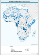
Robust derivative of VMap0 - Ed5 data layers harmonized with DCW dams, lakes, waterholes, wells and other SWBs based on the VMAP0-MP and DCW-DN/DSPNT sources. The DNIW_PNT shapefile data layer is comprised of 19230 derivative vector surface water bodies features derived based on 1:1 000 000 data originally from VMap0/DCW. The layer provides nominal analytical/mapping at 1:1 000 000. Seamlessly complete globally, with consolidation-harmonization @ ~70%, this Africa subset at final. Acronyms and Abbreviations: VMap0 - Vector Map for Level 0; DCW - Digital Chart of the World; SWBs - Surface Waterbodies, DNNET - Drainage Network layer; LCPOLY - Land Cover layer.
-

H1k_FLOW: River "flow accumulation" network from the HYDRO1k for Africa, reprojected to decimal degrees from Lambert Azimuthal Equal Area base, the only "networked" AWRD River layer. HYDRO1k is the Global Hydrological 1 kilometre database of hydrologically filled DEMs, "river" flow, and watershed networks based on the GTopo30. The H1K_FLOW shapefile data layer is comprised of 15478 derivative raster watershed and flow network features derived based on 4 000 cell data originally from HYDRO1k. The layer provides nominal analytical/mapping at 1:2 000 000. Data processing is complete globally, this is an African subset. HYDRO1k - HYDRO1k - Global Hydrological 1 kilometre database of hydrologically filled DEMs; AWRD - FAO-FIMA?s African Water Resources Database & Tools Interface; DEM - Digital Elevation Model.
-
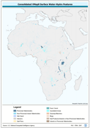
Seamless and topologically robust derivative of source VMap0 SWB and related hydrological features, i.e. swamps, etc. data layers. The VMAP_PY shapefile data layer is comprised of 25128 derivative vector framework library features derived based on 1:1 000 000 data originally from VMap0/DCW. The layer provides nominal analytical/mapping at 1:1 000 000. Seamlessly complete globally, with consolidation-harmonization @ ~70%, this Africa subset at final. Acronyms and Abbreviations: VMap0 - Vector Map for Level 0; SWB - Surface Water Body DCW - Digital Chart of the World.
-

Enhanced Rivers linear derivative based on 4 separate RWDB2 Library layers. The RWDB_RIV shapefile data layer is comprised of 4376 derivative line framework library features derived based on 1:3 000 000 data originally from . The layer provides nominal analytical/mapping at 1:3 000 000. Data processing is complete globally, this is an African subset. Acronyms and Abbreviations: RWDB2 or RWDB II- Relational World Database II.