 FAO Map Catalog
21-0
Type of resources
Available actions
Topics
Keywords
Contact for the resource
Provided by
Years
Representation types
Update frequencies
status
Scale
-

Ad2-Linear coastlines, national, 1st order subnational and other areas of sovereignty boundaries compiled from multiple RWDB2 source layers, circa 1997. The RWDB_AD2-LN shapefile data layer is comprised of 26648 derivative vector framework library features derived based on 1:3 000 000 data originally from RWDBII. The layer provides nominal analytical/mapping at 1:3 000 000. Data processing complete globally. Acronyms and Abbreviations: RWDB2 or RWDB II- Relational World Database II.
-

Point based representation of major port and harbours. The RWDB_PORT shapefile data layer is comprised of 4792 derivative vector framework library features derived based on 1:3 000 000 data originally from RWDBII. The layer provides nominal analytical/mapping at 1:3 000 000. Data processing complete globally. Acronyms and Abbreviations: RWDB2 or RWDB II- Relational World Database II.
-
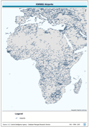
Point based representation of Airports. The RWDB_APRT shapefile data layer is comprised of 15044 derivative vector framework library features derived based on 1:3 000 000 data originally from RWDBII. The layer provides nominal analytical/mapping at 1:3 000 000. Data processing complete globally. Acronyms and Abbreviations: RWDB2 or RWDB II- Relational World Database II.
-
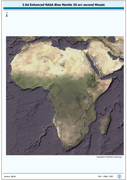
2.5d enhanced version of NASA Blue-Marble mosaic. The BLUMRBL_SHD image data layer is comprised of 9600x9600 derivative image satellite based imagery features derived based on 0.00833_ data originally from MODIS BlueMarble-1 generation.
-
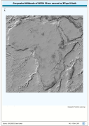
Grayscale hillshaded image of SRTM-30 terrestrial DEM and ETopo2 bathymetric data; SRTM is Shuttle Radar Topography Mission; DEM is Digital Elevation Model; ETopo2 is a 2 minute Elevation Topographic DEM including bathymetry. The SRTM30_HSHD image data layer is comprised of 9600x9600 derivative raster hillshade features derived based on 0.00833_ data originally from SRTM 30as v.2.
-
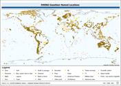
Point based gazetteer of named locations. The RWDB_GZTR shapefile data layer is comprised of 3031 derivative vector framework library features derived based on 1:3 000 000 data originally from RWDBII. The layer provides nominal analytical/mapping at 1:3 000 000. Data processing complete globally. Acronyms and Abbreviations: RWDB2 or RWDB II- Relational World Database II.
-

Point based representation of populated place with encoding differentiating national and subnational capitals and other related administrative centres. The RWDB_PPL shapefile data layer is comprised of 55038 derivative vector framework library features derived based on 1:3 000 000 data originally from RWDBII. The layer provides nominal analytical/mapping at 1:3 000 000. Data processing complete globally. Acronyms and Abbreviations: RWDB2 or RWDB II- Relational World Database II.
-

Ad1-Linear coastlines, national and other areas of sovereignty boundaries compiled from multiple RWDB2 source layers, circa 1997. The RWDB_AD1-LN shapefile data layer is comprised of 18870 derivative vector framework library features derived based on 1:3 000 000 data originally from RWDBII. The layer provides nominal analytical/mapping at 1:3 000 000. Data processing complete globally. Acronyms and Abbreviations: RWDB2 or RWDB II- Relational World Database II.