 FAO Map Catalog
2010
Type of resources
Available actions
Topics
Keywords
Contact for the resource
Provided by
Years
Formats
Representation types
Update frequencies
status
Scale
Resolution
-
**Table content** - Year - Indicator - Sector - Value - Flag - Unit
-
**Table content** - Year - Indicator - Sex - District - Value - Flag - Unit
-
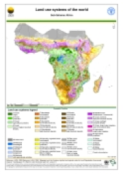
Version 1.1 of a thematic grid of Land Use Systems (LUS) and its attributes for Sub-Saharan Africa with a spatial resolution of 5 arc minutes or 0.083333 decimal degrees. This dataset is developed in the framework of the LADA project (Land degradation Assessment in Drylands) by the Land Tenure and Management Unit of the Food and Agriculture Organization of the United Nations and is copyright of FAO/UNEP GEF. The LUS map implementation is based on a innovative methodology combining more than 10 global datasets. Due to the map generation method, the quality of the map can never be uniform. The overall quality of the map depends heavily on the individual quality of the data for the different countries.
-

This dataset is a spatially reaggregated version of the original national full resolution landcover. The original full resolution dataset has been produced from visual interpretation of digitally enhanced LANDSAT TM images (30 m resolution). The land cover classes have been developed using the FAO/UNEP international standard LCCS classification system. This database can be analyzed in the GLCN software Advanced Database Gateway (ADG), which provides a user-friendly interface and advanced functionalities to breakdown the LCCS classes in their classifiers for further aggregations and analysis. Source: FAO-LADA Project The data set is intended for free public access.
-
**Table content** - Year - Indicator - Sex - Agricultural - Value - Flag - Unit
-
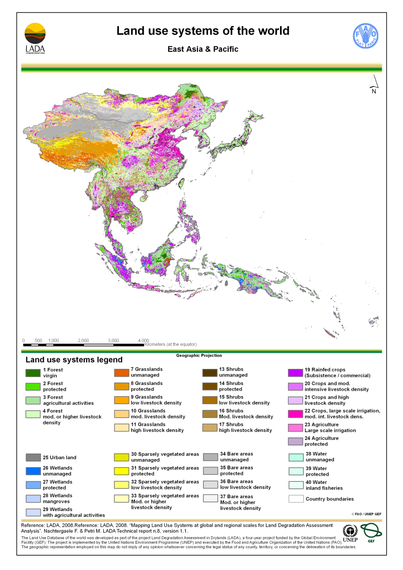
Version 1.1 of a thematic grid of Land Use Systems (LUS) and its attributes for East Asia and Pacific with a spatial resolution of 5 arc minutes or 0.083333 decimal degrees. This dataset is developed in the framework of the LADA project (Land degradation Assessment in Drylands) by the Land Tenure and Management Unit of the Food and Agriculture Organization of the United Nations and is copyright of FAO/UNEP GEF. The LUS map implementation is based on a innovative methodology combining more than 10 global datasets. Due to the map generation method, the quality of the map can never be uniform. The overall quality of the map depends heavily on the individual quality of the data for the different countries.
-
**Table content** - Year - Indicator - Product - Value - Flag - Unit
-
**Table content** - Year - Indicator - Product - Value - Flag - Unit
-

This dataset divides the Australian continent in major hydrological basins and their sub-basins according to its hydrological characteristics. It was obtained by delineating drainage basin boundaries from hydrologically corrected elevation data (WWF HydroSHEDS and Hydro1K). The dataset consists of the following information:- numerical code and name of the major basin (MAJ_BAS and MAJ_NAME); - area of the major basin in square km (MAJ_AREA); - numerical code and name of the sub-basin (SUB_BAS and SUB_NAME); - area of the sub-basin in square km (SUB_AREA); - numerical code of the sub-basin towards which the sub-basin flows (TO_SUBBAS) (the codes -888 and -999 have been assigned respectively to internal sub-basins and to sub-basins draining into the sea)
-
Version 1.1 of a thematic grid of Land Use Systems (LUS) and its attributes with a spatial resolution of 5 arc minutes or 0.083333 decimal degrees. This dataset is developed in the framework of the LADA project (Land degradation Assessment in Drylands) by the Land Tenure and Management Unit of the Food and Agriculture Organization of the United Nations and is copyright of FAO/UNEP GEF. The LUS map implementation is based on a innovative methodology combining more than 10 global datasets. Due to the map generation method, the quality of the map can never be uniform. The overall quality of the map depends heavily on the individual quality of the data for the different countries.