 FAO Map Catalog
2007
Type of resources
Available actions
Topics
Keywords
Contact for the resource
Provided by
Years
Formats
Representation types
Update frequencies
status
Scale
-
During National Science Week on Sunday 26th August 2007, Geoscience Australia opened its doors to the community to showcase a diverse range of work activities. Members of the public had the opportunity to discover how earthquakes are detected, pan for gold, tour the building, view Australia in 3D, become a seafloor detective and talk to the people who work for Australia's national geoscience research organisation. The photographs of that open day have been converted into thumbmail images and are available on the GA web site.
-
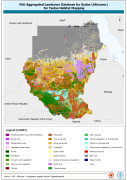
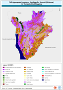
This dataset is an aggregated version of the original national Africover landcover multipurpose database. A 26-class legend is used to aggregate the classes present in the original full resolution, multipurpose landcover database. A single legend is applicable to the eight trypanosomiasis-affected countries mapped during Africover project (Burundi, Democratic Republic of the Congo, Kenya, Rwanda, Somalia, Sudan, Uganda and United Republic of Tanzania).
-
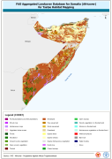
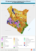
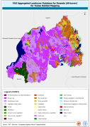

The FGGD inland water bodies map is a global raster datalayer with a resolution of 5 arc-minutes. It contains the value -997 where inland water bodies is present, the value 1 for the land. The information of inland water bodies is from the 1991 version of Digital Soil Map of the World.
-
The FGGD coastal and country boundaries of the world is a global datalayer that is available in both vector and raster formats, with a vector scale of 1:5 000 000 and a raster resolution of 5 arc-minutes. It contains coastal and country boundaries from Digital Soil Map of the World, updated to 2005 according to internationally-recognised changes reported by the UN Geographic Information Working Group (DPKO/UNCS).
-
Aggregated landcover database for United Republic of Tanzania (Africover) for tsetse habitat mapping
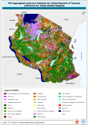
This dataset is an aggregated version of the original national Africover landcover multipurpose database. A 26-class legend is used to aggregate the classes present in the original full resolution, multipurpose landcover database. A single legend is applicable to the eight trypanosomiasis-affected countries mapped during Africover project (Burundi, Democratic Republic of the Congo, Kenya, Rwanda, Somalia, Sudan, Uganda and United Republic of Tanzania).
-
This dataset is an aggregated version of the original national Africover landcover multipurpose database. A 26-class legend is used to aggregate the classes present in the original full resolution, multipurpose landcover database. A single legend is applicable to the eight trypanosomiasis-affected countries mapped during Africover project (Burundi, Democratic Republic of the Congo, Kenya, Rwanda, Somalia, Sudan, Uganda and United Republic of Tanzania).