 FAO Map Catalog
2006
Type of resources
Available actions
Topics
Keywords
Contact for the resource
Provided by
Years
Representation types
Update frequencies
status
Scale
-
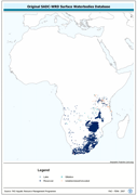
Enhanced derivative based on the original SADC-WRD database of lakes & impoundments, the SADC_SWB shapefile data layer is comprised of 18098 polygons, lakes, dams and reservoirs features derived based on 1:250 000 data originally from ALCOM. Acronyms and Abbreviations: SADC - The Southern African Development Community; WRD - The original SADC Water Resource Database produced by ALCOM; ALCOM - Aquatic Resource Management for Local Community Development Programme; SWB - Surface Water Body.
-
Consolidated Table of 2001 Decadal Rainfall. The RFE_2001 tabular data layer is comprised of 471688 derivative raster precipitation features derived based on 8 kilometers data originally from EDC. The layer provides nominal analytical/mapping at 1:3 500 000. Acronyms and Abbreviations: EDC - USGS EROS (Earth Resources Observation Systems) Data Center.
-
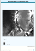
Lake Tanganyika SRTM 3 as DEM Mosaic. The DEM_MOS grid data layer is comprised of 14401x16801 derivative raster digital elevation model features derived based on 0.000833_ data originally from SRTM. The layer provides nominal analytical/mapping at 1:250 000. Acronyms and Abbreviations: SRTM - Shuttle Radar Topography Mission DEM - Digital Elevation Model
-
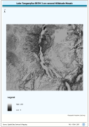
Lake Tanganyika SRTM 3 as Hillshade Mosaic. The HSHD_MOS grid data layer is comprised of 14401x16801 derivative raster hillshade features derived based on 0.000833_ data originally from SRTM. The layer provides nominal analytical/mapping at 1:250 000. Acronyms and Abbreviations: DEM - Digital Elevation Model
-
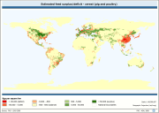
The map shows the estimated cereal feed surplus and deficit for use in both pig and poultry livestock production, at a resolution of 100 x 100 km cells, for the whole world.
-
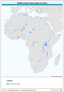
This dataset derives from the RWDB_SWB-PY shapefile data layer which covers the entire globe and is comprised of 8750 derivative vector framework library features derived based on 1:3,000,000 data originally from RWDBII. The original dataset is an enhanced SWB polygonal derivative based on 4 separate RWDB2 Library layers. The layer provides nominal analytical/mapping at 1:3,000,000. Acronyms and Abbreviations: RWDB2 or RWDB II- Relational World Database II SWB - Surface Water Body