 FAO Map Catalog
2004
Type of resources
Available actions
Topics
Keywords
Contact for the resource
Provided by
Years
Formats
Representation types
Update frequencies
status
Scale
Resolution
-

Rinderpest is an OIE List A disease. The standards, included in the International Animal Health Code, and known as the 'OIE Rinderpest Pathway', are the requirements that must be met to obtain official OIE recognition of country/zone freedom from this disease .The map shows the countries and zones by countries that are self-declared provisionally free from rinderpest disease. This information published by the OIE is derived from declarations made by the official Veterinary Services of Member Countries to OIE. The map shows also the countries recognised by OIE, as free from rinderpest disease and rinderpest infection.
-
Grid with estimated reference evapotranspiration per month with a spatial resolution of 10 arc minutes. The dataset contains mean monthly values for global land areas, excluding Antarctica, for the period 1961-1990. The dataset has been prepared according to the FAO Penman - Monteith method with limited climatic data as described in FAO Irrigation and Drainage Paper 56. The dataset consists of 12 ASCII-grids with mean monthly data in mm/day * 10, and one ASCII-grid with yearly data in mm/year.
-
Grid with estimated yearly reference evapotranspiration with a spatial resolution of 10 arc minutes. The dataset contains average values for global land areas, excluding Antarctica, for the period 1961-1990. The dataset has been prepared according to the FAO Penman - Monteith method with limited climatic data as described in FAO Irrigation and Drainage Paper 56. The dataset consists one ASCII-grid with yearly data in mm/year. ASCII-grids with mean monthly data in mm/day * 10 are also available as described in the associated resources of this metadata.
-
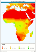
Annual Total Precipitation. The PRCP_YR grid data layer is comprised of 1080x2160 derivative raster precipitation features derived based on 0.167 degrees resolution data originally from CRU. Monthly precipitation from January to December is also available for download. Acronyms and Abbreviations: CRU - Climatic Research Unit - School of Environmental Sciences, University of East Anglia - Norwich.
-

Terrestrial Ecoregions of the World (TEOW) is a biogeographic regionalization of the Earth's terrestrial biodiversity. Our biogeographic units are ecoregions, which are defined as relatively large units of land or water containing a distinct assemblage of natural communities sharing a large majority of species, dynamics, and environmental conditions. There are 867 terrestrial ecoregions, classified into 14 different biomes such as forests, grasslands, or deserts. Ecoregions represent the original distribution of distinct assemblages of species and communities. The map has been produced by the Conservation Science Program of the World Wildlife Fund.