 FAO Map Catalog
2003
Type of resources
Available actions
Topics
Keywords
Contact for the resource
Provided by
Years
Formats
Representation types
Update frequencies
status
Scale
-

Rift Valley fever is an OIE list A disease.The map shows the last reported outbreaks of Rift Valley fever in different countries of Africa and Middle East
-
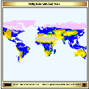
Aridity index (P/Pet) derived from IDRISI file with continuous data, reclassified into 6 classes (+ water bodies); The 6th class indicates cold climate derived from Thermal climates (Boreal and Arctic) received from IIASA in 2002. The IDRISI file with Aridity values was received by IIASA on February 2003.
-
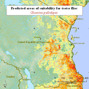
The dataset contains the predicted areas of suitability for five tsetse fly species (morsitans, pallidipes, austeni, brevipalpis and swynnertoni). All of the distributions have been produced using variations of the same methodology - by modelling the "known" presence and absence of the flies (usually the 1977 Ford and Katondo maps modified with more recent information collected from national and international agencies and researchers). The modelling process relies on logistic regression of fly presence against a wide range of predictor variables for a large number of regularly spaced sample points for each area. The predictor variables include remotely sensed (satellite image) surrogates of climate - vegetation, temperature, moisture - which have been subjected to Fourier processing to provide an additional set of season and timing related measures for each parameter. Demographic, topographic and agroecological predictors are also used. These models are then applied to the predictor imagery to determine the predicted areas of suitability for tsetse. Data are provided at 1 kilometre resolution. The maps were produced in May 2003 for FAO/IAEA Joint Division by Environmental Research Group Oxford (ERGO Ltd) in collaboration with the Trypanosomosis and Land Use in Africa (TALA) research group.
-

Dryland map derived from the Aridity index map (P/PET).
-
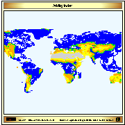
Aridity index (P/Pet) derived from IDRISI file with continuous data, reclassified into 5 classes (+ water bodies). The IDRISI file was received by IIASA on February 2003.