 FAO Map Catalog
1996
Type of resources
Available actions
Topics
Keywords
Contact for the resource
Provided by
Years
Representation types
Update frequencies
status
Scale
-
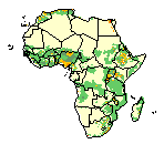
Population density estimates per sqkm.
-
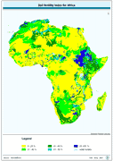
Soil fertility index for Africa derived from the FAO/UNESCO Digital Soil Map of the World interpreted in terms of soil fertility.
-
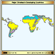
Map showing 16 major climate classes for the Developing World. Digital version of "Major Climatic Divisions" derived from the Agro-Ecological Zones Project, made by FAO in 1978. Refer to World Soil Resources Report 48, Vol. 1 Methodology and Results for Africa; Vol. 2 Results for Southwest Asia; Vol. 3 Methodology and Results for South and Central America; Vol. 4 results for Near East.
-

Map showing 35 lengths of growing period zones for the developing world. Digital version of "Major Climatic Divisions" derived from the Agro-Ecological Zones Project, made by FAO in 1978. Refer to World Soil Resources Report 48, Vol. 1 Methodology and Results for Africa; Vol. 2 Results for Southwest Asia; Vol. 3 Methodology and Results for South and Central America; Vol. 4 results for Near East.
-

Map showing 8 major climate classes for Africa. Digital version of "Major Climatic Divisions" derived from the Agro-Ecological Zones Project, made by FAO in 1978. Refer to World Soil Resources Report 48, Vol. 1 Methodology and Results for Africa.