 FAO Map Catalog
14-1
Type of resources
Available actions
Topics
Keywords
Contact for the resource
Provided by
Years
Representation types
Update frequencies
status
Scale
-
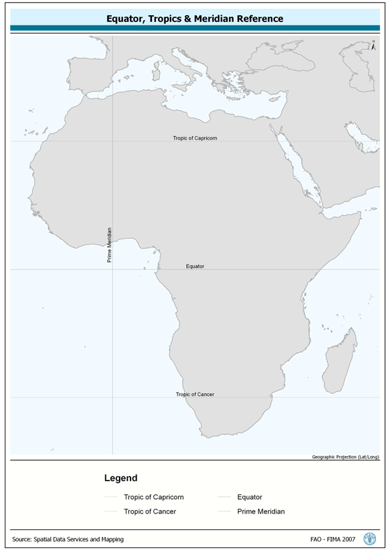
Provides spatial reference for Tropics of Capricorn and Cancer, the Equator and the Prime Meridian. The TROP_REF shapefile data layer is comprised of 4 derivative line reference lines for tropics-equator-meridian features derived based on 1:1 000 000 data originally from FIRI. The layer provides nominal analytical/mapping at 1:1 000 000. Acronyms and Abbreviations: FIRI - Inland Water resources and Aquaculture Service, recently changed in FIMA - Aquaculture Management and Conservation Service.
-
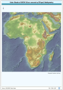
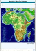
2.5d enhanced RGB of SRTM-30 terrestrial elevation and ETopo2 bathymetric data. RGB is 3 band spatial imagery forced into the Red:Green:Blue spectrum; SRTM is Shuttle Radar Topography Mission; ETopo2 is a 2 minute Elevation Topographic DEM including bathymetry. The SRTM30_SHDBATH image data layer is comprised of 9600x9600 derivative raster digital elevation model features derived based on 0.00833_ data originally from SRTM 30as v.2.
-
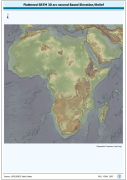
RGB Image with Ortho-Flattened effect for terrestrial and bathymetric elevation data. RGB is 3 band spatial imagery forced into the Red:Green:Blue spectrum. The SRTM30_FLAT image data layer is comprised of 9600x9600 derivative raster digital elevation model features derived based on 0.00833_ data originally from SRTM 30as v.2.
-
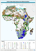
Derived from 1:250 000 scale topographic maps and information from SADC host country ministries on impondments and reservoirs. The SWB_SADC tabular data layer is comprised of 18098 derivative tabular/point sadc lakes, dams and reservoirs features derived based on 1:250 000 data originally from ALCOM. The layer provides nominal analytical/mapping at 1:250 000. Acronyms and Abbreviations: SADC - The Southern African Development Community; WRD - The original SADC Water Resource Database produced by ALCOM; ALCOM - ALCOM - Aquatic Resource Management for Local Community Development Programme; SWB - Surface Water Body.
-

Full value-added derivative of ASCII GEOnet January 2006 gazetteer baseline, including non-diacritical names. ASCII is American Standard Code for Information Interchange. The GNS_GZTR shapefile data layer is comprised of 1083354 derivative point gazetteer features derived based on 1:250 000 data originally from GEOnet. The layer provides nominal analytical/mapping at 1:250 000. Data processing is complete globally, this is an African subset. Acronyms and Abbreviations: ASCII - American Standard Code for Information Interchange; GNS/GeoNet - NIMA?s Geographic Names Server Gazetteer of Named Locations.
-
GNS_RIV: GNS/GeoNet named river confluence & outflow locations Value-added derivative of source w/non-diacritical names of river confluence's. The GNS_RIV shapefile data layer is comprised of 138700 derivative point gazetteer features derived based on 1:250 000 data originally from GEOnet. The layer provides nominal analytical/mapping at 1:250 000. Data processing is complete globally, this is an African subset. Acronyms and Abbreviations: GNS/GeoNet - NIMA?s Geographic Names Server Gazetteer of Named Locations; NIMA - U.S. National Imagery & Mapping Agency, formerly the U.S. Defense Mapping Agency (DMA).
-
A Shaded relief image based on the first globally available elevation model. The AFRICA_BACKGROUND image data layer is comprised of 973x985 derivative raster bathymetry and elevation features derived based on 0.08333_ data originally from ETOPO5.
-
GNS_SWB: Surface Water Bodies based on named locations GNS/GeoNet Gazetteer. The GNS_SWB shapefile data layer is comprised of 46591 derivative point gazetteer features derived based on 1:250 000 data originally from GEOnet. The layer provides nominal analytical/mapping at 1:250 000. Data processing is complete globally, this is an African subset. Acronyms and Abbreviations: GNS/GeoNet Gazetteer - NIMA's Geographic Names Server Gazetteer of Named Locations; SWB - Surface Water Body.