 FAO Map Catalog
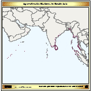
Agroclimatic Stations
The layer provides the agro-climatic stations located on the Asian coastal areas affected by the Tsunami.
Simple
- Date ( Creation )
- 2005
- Edition
- first
- Presentation form
- Digital map
- Status
- Completed
Point of contact
FAO-UN - Climate and Environment Division (CBC)
-
Hideki Kanamaru
(
Natural Resources Officer
)
- Maintenance and update frequency
- As needed
- Keywords ( Theme )
-
- agro-climatic station
- agromet
- tsunami
- Tag_climate
- Keywords ( Place )
-
- East & South East Asia
- Access constraints
- Copyright
- Use constraints
- Copyright
- Spatial representation type
- Vector
- Metadata language
- eng
- Character set
- UTF8
- Topic category
-
- Climatology, meteorology, atmosphere
N
S
E
W
))
- Supplemental Information
- The stations are located in the following Countries: Bangladesh, India, Indonesia, Malaysia, Myanmar, Somalia, Sri Lanka and Thailand. Information on data collected by those stations are available on the Tsunami Reconstruction FAO webside, through the Agroclimatic Data link
- Protocol
- WWW:LINK-1.0-http--link
- OnLine resource
-
stations.zip
(
WWW:DOWNLOAD-1.0-http--download
)
Agroclimatic Stations - Shapefile Format
- Hierarchy level
- Dataset
gmd:MD_Metadata
- File identifier
- f8fc5200-88fd-11da-a88f-000d939bc5d8 XML
- Metadata language
- eng
- Character set
- UTF8
- Date stamp
- 2019-11-22T10:31:52
- Metadata standard name
- ISO 19115:2003/19139
- Metadata standard version
- 1.0
Point of contact
FAO-UN - Climate and Environment Division (CBC)
-
Hideki Kanamaru
(
Natural Resources Officer
)
Viale delle Terme di Caracalla
,
Rome
,
00153
,
Italy
Overviews
thumbnail
large_thumbnail
Spatial extent
N
S
E
W
Provided by

Associated resources
Not available