 FAO Map Catalog
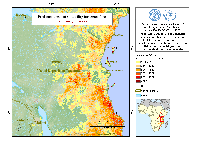
Predicted areas of suitability for tsetse flies: Tanzania
Simple
- Date ( Creation )
- 2003-05-01
- Edition
- first
- Presentation form
- Digital map
- Status
- Completed
- Maintenance and update frequency
- As needed
- Keywords ( Theme )
-
- african tripanosomiasis
- Keywords ( Place )
-
- Tanzania, United Rep of
- Access constraints
- Copyright
- Spatial representation type
- Grid
- Denominator
- 10000000
- Metadata language
- eng
- Character set
- UTF8
- Topic category
-
- Farming
- Begin date
- 2000-01-01
- End date
- 2007-12-31
))
- Reference system identifier
- WGS 1984
- Number of dimensions
- 1012
- Dimension name
- Column
- Dimension size
- 734
- Resolution
- 0.01 ,
- Cell geometry
- Area
- Transformation parameter availability
- No
- Distribution format
-
-
TIFF
(
)
-
TIFF
(
)
- OnLine resource
-
Programme Against African Trypanosomiasis - Information System
(
WWW:LINK-1.0-http--link
)
Programme Against African Trypanosomiasis - Information System
- OnLine resource
-
tsetse_species.zip
(
WWW:DOWNLOAD-1.0-http--download
)
Tsetse flies: predicted areas of suitability
- OnLine resource
-
Environmental Research Group Oxford
(
WWW:LINK-1.0-http--link
)
Environmental Research Group Oxford
gmd:MD_Metadata
- File identifier
- f8861090-88fd-11da-a88f-000d939bc5d8 XML
- Metadata language
- eng
- Character set
- UTF8
- Date stamp
- 2024-04-03T11:28:08
- Metadata standard name
- ISO 19115:2003/19139
- Metadata standard version
- 1.0
Overviews
Spatial extent
Provided by
