 FAO Map Catalog
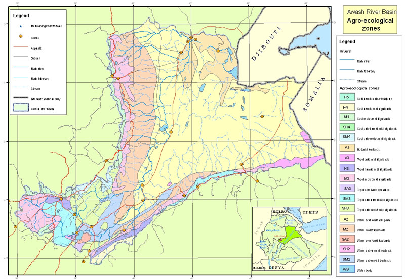
Awash River Basin: climatic data
Awash River Basin climatic data used for the project GCP/GLO/207/ITA.
The dataset includes: agroecological zones, meteorological stations, rainfall isohyets.
Data downloadable upon permission given by owner (Ethiopian Ministry of Water and Energy). Please contact the data distributor or any other points of contact associated to this metadata.
Simple
- Date ( Publication )
- 2008-01-01T00:00:00
- Edition
- Version 1
- Presentation form
- Digital map
- Purpose
- Assessment of agricultural water requirements.
- Status
- Completed
Distributor
FAO Ethiopia
-
Yibeltal Tiruneh
(
Irrigation Officer
)
FAOR P.O. Box 5536
,
Addis Ababa
,
Ethiopia
- Maintenance and update frequency
- As needed
- Keywords ( Theme )
-
- watersheds
- hydrology
- irrigation
- Tag_AQUASTAT
- Keywords ( Place )
-
- Ethiopia
- Access constraints
- Restricted
- Spatial representation type
- Vector
- Denominator
- 500000
- Metadata language
- eng
- Character set
- UTF8
- Topic category
-
- Inland waters
N
S
E
W
))
- Supplemental Information
- Data downloadable upon permission given by owner (Ethiopian Ministry of Water and Energy). Please contact the data distributor or any points of contact associated to this metadata.
- Reference system identifier
- Adindan_UTM_Zone_37N
- Topology level
- Geometry only
- Geometric object type
- Complex
- Units of distribution
- shapefile
- OnLine resource
-
Agricultural Water Management Information System of Ethiopia
(
WWW:LINK-1.0-http--link
)
Information
- Protocol
- WWW:LINK-1.0-http--link
- Name
- DVD
- Hierarchy level
- Dataset
gmd:MD_Metadata
- File identifier
- d23a4d53-214d-4d7c-8650-3e03daa59c64 XML
- Metadata language
- eng
- Character set
- UTF8
- Date stamp
- 2021-07-19T15:34:08
- Metadata standard name
- ISO 19115:2003/19139
- Metadata standard version
- 1.0
Point of contact
FAO-UN Land and Water Division
-
AQUASTAT
(
)
Viale delle Terme di Caracalla
,
Rome
,
Italy
Overviews
thumbnail
large_thumbnail
Spatial extent
N
S
E
W
Provided by

Associated resources
Not available