 FAO Map Catalog
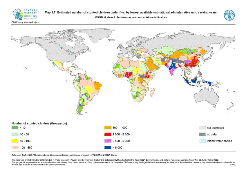
Estimated number of stunted children under five, by lowest available subnational administrative unit, varying years (FGGD)
The FGGD estimated number of stunted children map is a global raster datalayer with a resolution of 5 arc-minutes. The number of stunted children is estimated according to the lowest available sub-national administrative units: all pixels within the unit boundaries will have the same value, that means the estimated number of stunted children in the unit. Data have been compiled by FAO using three main information: the prevalence of stunting, LandScan global population database and the percentage of children under five. This last information is at national level and its source is UNICEF.
Simple
- Date ( Publication )
- 2007-06-25
- Edition
- 1.0
- Presentation form
- Digital map
- Purpose
- The FGGD Digital Atlas consists of more than 100 global database that allows to analyse food insecurity and poverty in relation to the environment.
- Status
- Completed
Point of contact
FAO - GIS UNIT
-
GIS Manager
Viale delle Terme di Caracalla, 1
,
Rome
,
00153
,
Italy
- Maintenance and update frequency
- As needed
- Keywords ( Theme )
-
- community development
- social development
- poverty
- malnutrition
- undernutrition
- health
- Keywords ( Place )
-
- World
- Access constraints
- Copyright
- Use constraints
- Copyright
- Spatial representation type
- Grid
- Metadata language
- eng
- Character set
- UTF8
- Topic category
-
- Society
- Health
N
S
E
W
))
- Geographic identifier
- GCS_WGS_1984
- Supplemental Information
- This dataset is contained in Module 3 "Socio-economics and nutrition indicators" of Food Insecurity, Poverty and Environment Global GIS Database (FGGD) (FAO, 2007).
- Reference system identifier
- GCS_WGS_1984
- Number of dimensions
- 2
- Dimension name
- Row
- Dimension size
- 2160
- Resolution
- 0.08333333 ,
- Dimension name
- Column
- Dimension size
- 4320
- Resolution
- 0.08333333 ,
- Cell geometry
- Area
- Transformation parameter availability
- Yes
- Distribution format
-
-
TIFF
(
)
-
TIFF
(
)
- OnLine resource
-
Map3_7.zip
(
WWW:DOWNLOAD-1.0-http--download
)
Estimated number of stunted children under five, by lowest available subnational administrative unit, varying years
- OnLine resource
-
geonetwork:stunted_chl_14055
(
OGC:WMS-1.1.1-http-get-map
)
Estimated number of stunted children under five
Data quality info
No information provided.
gmd:MD_Metadata
- File identifier
- cd68fef0-68f8-11db-a5a5-000d939bc5d8 XML
- Metadata language
- eng
- Character set
- UTF8
- Date stamp
- 2023-02-03T10:06:48
- Metadata standard name
- ISO 19115:2003/19139
- Metadata standard version
- 1.0
Point of contact
FAO - GIS UNIT
-
Mirella Salvatore
(
Consultant
)
Via delle Terme di Caracalla, 1
,
Rome
,
00153
,
Italy
Overviews

thumbnail
large_thumbnail
Spatial extent
N
S
E
W
Provided by

Associated resources
Not available