 FAO Map Catalog
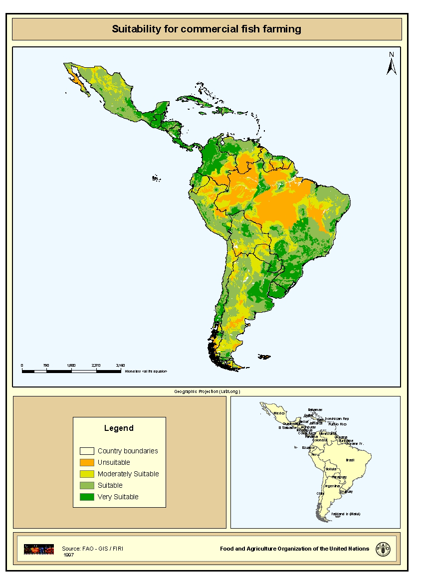
Suitability for commercial fish farming
Areas with suitability for commercial fish farming development and operation. Map derived from the combined suitability of five land-quality factors important for fish farming development and operation; net annual water loss from ponds through evaporation and seepage; soil and terrain suitability for ponds; potential for agriculture by-products and fertiliser inputs; potential for farm gate sales; and potential market demand.
Simple
- Date ( Publication )
- 1997-01-01
- Edition
- First
- Presentation form
- Digital map
- Purpose
- The overall purpose is to stimulate aquaculture development
- Status
- Completed
- Keywords
-
- Fishery
- Fish farming
- Aquaculture
- Latin America and the Caribbean
- COPESCAL Technical Paper 10
- Keywords ( Place )
-
- Latin America
- Spatial representation type
- Grid
- Metadata language
- eng
- Character set
- UTF8
- Topic category
-
- Economy
- Begin date
- 1994-01-01
- End date
- 1996-01-01
N
S
E
W
))
- Supplemental Information
- This map derives from a wider study that evaluates inland fish farming potential at a continental-level, published by J.M. Kapetsky and S. S. Nath with the title "A strategic assessment of the potential for freshwater fish farming in Latin America " . COPESCAL Technical Paper. No. 10. Rome, FAO. 1997. 128p. Resolution 9 km x 9 km.
- OnLine resource
- http://www.fao.org/fi/newslet/fan13/inland.asp; ( WWW:LINK-1.0-http--link )
- OnLine resource
- http://biosys.bre.orst.edu/crspDB/publications/view_detail.cfm?PubIndex ( WWW:LINK-1.0-http--link )
- OnLine resource
-
geonetwork:com_mld_3847
(
OGC:WMS-1.1.1-http-get-map
)
Suitability for commercial fish farming
- OnLine resource
-
comerc.zip
(
WWW:DOWNLOAD-1.0-http--download
)
Suitability for commercial fish farming (GRID format)
- Hierarchy level
- Dataset
- Statement
- Conversion from ASCII files to Arc/Info GRID
gmd:MD_Metadata
- File identifier
- ca5d8180-88fd-11da-a88f-000d939bc5d8 XML
- Metadata language
- eng
- Character set
- UTF8
- Date stamp
- 2009-04-14T17:52:53
- Metadata standard name
- ISO 19115:2003/19139
- Metadata standard version
- 1.0
Overviews
thumbnail
large_thumbnail
Spatial extent
N
S
E
W
Provided by

Associated resources
Not available