 FAO Map Catalog
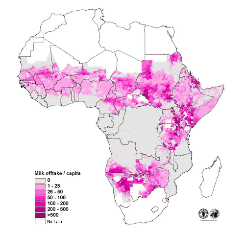
Estimated milk offtake (kg) per capita in Sub-Saharan Africa
Based on bovine and human population densities (FAO, 1999), livestock systems distribution, system-specific production parameters, calculations of output per animal to obtain milk offtake per capita were performed using the Livestock Development Planning System Version 2 model. Part of a study "Cattle and small ruminant production systems in sub-Saharan Africa: a systematic review" (FAO, 2002).
Simple
- Date ( Creation )
- 2002
- Edition
- First
- Presentation form
- Digital map
- Purpose
- Distribution of milk offtake per capita in sub-Saharan Africa
- Status
- Completed
Point of contact
FAO - AGAL
-
Tim Robinson
(
Livestock Information Officer
)
Via delle Terme di Caracalla
,
Rome
,
RM
,
00100
,
Italy
(39) 06 570 54901
- Hours of service
- 8.30 - 17.00
- Keywords ( Theme )
-
- bovine
- livestock
- density
- milk production
- food production
- livestock products
- per capita production
- Tag_AGAL
- Keywords ( Place )
-
- Sub Sahara
- Spatial representation type
- Grid
- Metadata language
- eng
- Character set
- UTF8
- Topic category
-
- Farming
- Begin date
- 1994
N
S
E
W
))
- Reference system identifier
- Geographic System lat/log
- Number of dimensions
- 2
- Dimension name
- Row
- Dimension size
- 2539
- Dimension name
- Column
- Dimension size
- 3386
- Cell geometry
- Area
- Hierarchy level
- Dataset
gmd:MD_Metadata
- File identifier
- c97432f0-88fd-11da-a88f-000d939bc5d8 XML
- Metadata language
- eng
- Character set
- UTF8
- Date stamp
- 2004-10-27T14:13:11
- Metadata standard name
- ISO 19115:2003/19139
- Metadata standard version
- 1.0
Overviews

thumbnail
large_thumbnail
Spatial extent
N
S
E
W
Provided by

Associated resources
Not available