 FAO Map Catalog
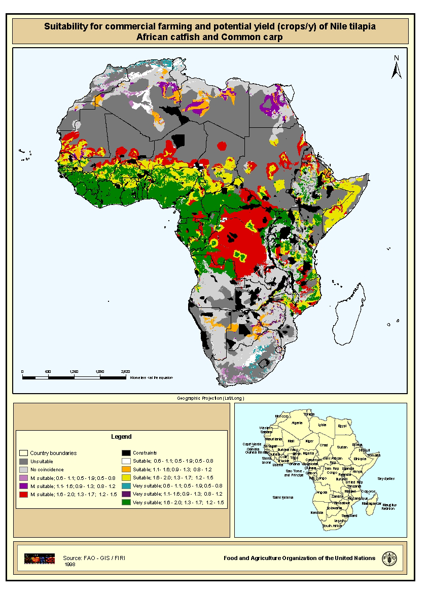
Suitability for commercial farming and potential yield (crops/y) of Nile tilapia, African catfish and Common carp
Map derived from the combined suitability of areas apt for commercial fish farming development and operation with areas with potential yield (crops/y) of Nile tilapia, African catfish and Common carp for small-scale farming. Areas with suitability for commercial fish farming were derived from the combined suitability of five land-quality factors important for fish farming development and operation; net annual water requirement for shallow ponds, soil and terrain suitability for the construction of fish ponds, potential livestock wastes and agriculture by-products as feed and fertilizer inputs, potential for farm-gate sales and potential market demand. Predictions of growth were based on water temperature, in turn predicted from air temperature and wind velocity data. Gridded values of mean monthly daily minimum and maximum temperatures were obtained from the Centre for Resource and Environmental Studies (CRES) at the Australian National University. Mean annual wind velocity was obtained from UNEP/DEIA/GRID-Geneva.
Simple
- Date ( Publication )
- 1998-01-01
- Edition
- First
- Presentation form
- Digital map
- Purpose
- The main objective was to map and estimate the areal expanses having suitable to optimum potential for subsistence and commercial warm water fish farming in ponds. A secondary objective was to encourage countries with relatively large potentials for warm water fish farming development to undertake more detailed, national-level studies as a step towards formulating or refining an aquaculture policy and to improve planning for aquaculture development.
- Status
- Completed
- Keywords
-
- Africa
- Fishery
- Fish farming
- Commercial farming
- Yield
- Aquaculture
- CIFA Technical Paper 32
- Keywords ( Place )
-
- Africa
- Spatial representation type
- Grid
- Metadata language
- eng
- Character set
- UTF8
- Topic category
-
- Economy
- Begin date
- 1997-01-01
- End date
- 1998-01-01
N
S
E
W
))
- Supplemental Information
- This map derives from a wider study that evaluates inland fish farming potential at a continental-level, published by J.Aguilar-Manjarrez and S. S. Nath with the title "A strategic reassessment of fish farming potential in Africa". CIFA Technical Paper. No. 32. Rome, FAO. 1998. 170p. This study is a follow-up of an earlier assessment of warm-water fish farming potential in Africa by Kapetsky (1994) with the objective to assess locations and areal expanses that have potential for warm-water and temperate-water fish farming in continental Africa. Resolution 5 km x 5 km.
- OnLine resource
- http://www.fao.org/docrep/W8522e/W8522E00.htm#TOC ( WWW:LINK-1.0-http--link )
- OnLine resource
- http://cres.anu.edu.au/software/africatxt.htm ( WWW:LINK-1.0-http--link )
- OnLine resource
- http://www.iiasa.ac.at/ ( WWW:LINK-1.0-http--link )
- OnLine resource
-
geonetwork:s_comerc_3816
(
OGC:WMS-1.1.1-http-get-map
)
Suitability for commercial farming and potential yield (crops/y) of Nile tilapia, African catfish and Common carp
- OnLine resource
-
s_comerc.zip
(
WWW:DOWNLOAD-1.0-http--download
)
Suitability for commercial farming and potential yield (crops/y) of Nile tilapia, African catfish and Common carp (GRID format)
- Hierarchy level
- Dataset
- Statement
- Conversion from ASCII files to Arc/Info GRID
gmd:MD_Metadata
- File identifier
- c1a4aff0-88fd-11da-a88f-000d939bc5d8 XML
- Metadata language
- eng
- Character set
- UTF8
- Date stamp
- 2009-04-14T15:53:10
- Metadata standard name
- ISO 19115:2003/19139
- Metadata standard version
- 1.0
Overviews
thumbnail
large_thumbnail
Spatial extent
N
S
E
W
Provided by

Associated resources
Not available