 FAO Map Catalog
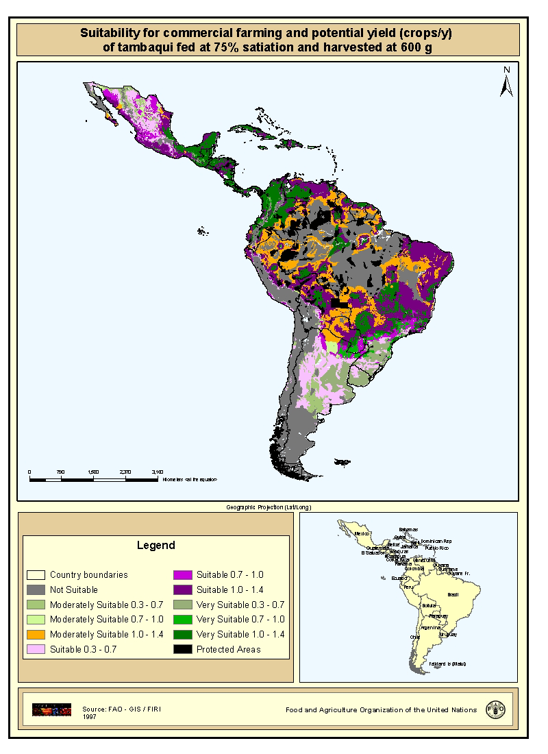
Suitability for commercial farming and potential yield (crops/y) of tambaqui fed at 75% satiation and harvested at 600 g
Map derived from the combined suitability of areas apt for commercial fish farming development and operation with areas with potential yield (crops/y) of tambaqui fed at 75% satiation and harvested at 600g. Suitable areas for commercial fish farming were derived from the combined suitability of five land-quality factors important for fish farming development and operation; net annual water loss from ponds through evaporation and seepage; soil and terrain suitability for ponds; potential for agriculture by-products and fertiliser inputs; potential for farm gate sales; and potential market demand. Yield estimations for tambaqui were based on water temperature which in turn were predicted from air temperature. Mean maximum and minimum monthly air temperatures grids were provide by FAO's Agrometeorology group. In order to explore a range of commercial aquaculture possibilities by the use of the growth model, simulations were conducted for tambaqui, assuming two different feeding levels and two harvesting weights (600 and 1,000 g). Feed application rates corresponding to 50% and 75% satiation were assumed to represent commercial aquaculture operations with low and high feeding rates, respectively.
Simple
- Date ( Publication )
- 1997-01-01
- Edition
- First
- Presentation form
- Digital map
- Purpose
- The overall purpose is to stimulate aquaculture development
- Status
- Completed
- Keywords
-
- Fishery
- Fish farming
- Aquaculture
- Latin America and the Caribbean
- COPESCAL Technical Paper 10
- Keywords ( Place )
-
- Latin America
- Spatial representation type
- Grid
- Metadata language
- eng
- Character set
- UTF8
- Topic category
-
- Economy
- Begin date
- 1994-01-01
- End date
- 1996-01-01
N
S
E
W
))
- Supplemental Information
- This map derives from a wider study that evaluates inland fish farming potential at a continental-level, published by J.M. Kapetsky and S. S. Nath with the title "A strategic assessment of the potential for freshwater fish farming in Latin America " . COPESCAL Technical Paper. No. 10. Rome, FAO. 1997. 128p. Resolution 9 km x 9 km.
- OnLine resource
- http://www.fao.org/fi/newslet/fan13/inland.asp; ( WWW:LINK-1.0-http--link )
- OnLine resource
- http://biosys.bre.orst.edu/crspDB/publications/view_detail.cfm?PubIndex ( WWW:LINK-1.0-http--link )
- Protocol
- WWW:LINK-1.0-http--link
- Function
- Information
- OnLine resource
-
s_tbcom.zip
(
WWW:DOWNLOAD-1.0-http--download
)
Suitability for commercial farming and potential yield (crops/y) of tambaqui fed at 75% satiation and harvested at 600 g (GRID format)
- Hierarchy level
- Dataset
- Statement
- Conversion from ASCII files to Arc/Info GRID
gmd:MD_Metadata
- File identifier
- c1a06a30-88fd-11da-a88f-000d939bc5d8 XML
- Metadata language
- eng
- Character set
- UTF8
- Date stamp
- 2009-04-14T17:52:04
- Metadata standard name
- ISO 19115:2003/19139
- Metadata standard version
- 1.0
Overviews
thumbnail
large_thumbnail
Spatial extent
N
S
E
W
Provided by

Associated resources
Not available