FAO Map Catalog
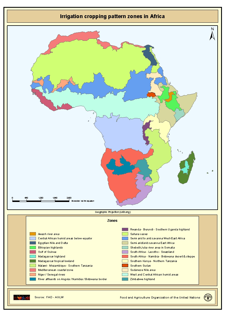
Irrigation cropping pattern zones in Africa
Irrigation cropping pattern zones in Africa which are considered to be homogeneous with respect to crop calendar and cropping intensity. The delineation of the irrigation cropping pattern zones was done by compiling information of various types: distribution of irrigated crops, average rainfall trends and patterns, topographic gradients, presence of large river valleys (Nile, Niger, Senegal), presence of extensive wetlands (the Sudd in Sudan), population pressure, technological differences and crop calendar above and below the equator.
The dataset consists of the following information: - GIS generated codes (FID, ID); - a code with an unique number to identify the cropping pattern zone (PATRN_CODE); - a code with the name of the cropping pattern zone (PATRN_NAME); - the cropping pattern, crop calendar and monthly and yearly cropping intensities for the different zones are described in the on-line link below (Table 1).
The map with irrigation cropping pattern zones is based on the FAO publication on Irrigation potential in Africa - FAO, 1997. Irrigation potential in Africa - A basin approach. FAO Land and Water Bulletin. Rome 177 p.
Simple
- Date ( Creation )
- 2000
- Edition
- First edition.
- Presentation form
- Digital map
- Purpose
- To calculate irrigation water requirements it is necessary to know the irrigated crops grown, the cropping calendar and the cropping intensity. All these factors are represented in this dataset, which is developed as part of an assessment of water used by irrigated agriculture in Africa.
- Status
- Completed
- Keywords ( Theme )
-
- irrigation
- crop calendar
- cropping pattern
- cropping intensity
- Tag_AQUASTAT
- Keywords ( Place )
-
- Africa
- Spatial representation type
- Vector
- Denominator
- 5000000
- Metadata language
- eng
- Character set
- UTF8
- Topic category
-
- Farming
))
- Supplemental Information
- The dataset has been published in the framework of the AQUASTAT - programme of the Land and Water Division of the Food and Agriculture Organization of the United Nations, as part of FAO Land and Water Digital Media Series #13: "Atlas of Water Resources and Irrigation in Africa".
- OnLine resource
-
Table 1: Irrigation cropping pattern zones and cropping intensity
(
WWW:LINK-1.0-http--link
)
Table 1: Irrigation cropping pattern zones and cropping intensity
- OnLine resource
-
Online link to the 'Water Resources and Irrigation in Africa' - website
(
WWW:LINK-1.0-http--link
)
Online link to the 'Water Resources and Irrigation in Africa' - website
- OnLine resource
- irr_zone.axl ( WWW:LINK-1.0-http--link )
- OnLine resource
-
irr_zone.zip
(
WWW:DOWNLOAD-1.0-http--download
)
Irrigation cropping pattern zones in Africa - shape file
- OnLine resource
-
geonetwork:irr_zone_283
(
OGC:WMS-1.1.1-http-get-map
)
Irrigation cropping pattern zones in Africa
- Hierarchy level
- Dataset
- Description
- Last Updated
- Date / Time
- 2002-05-31
gmd:MD_Metadata
- File identifier
- bdc049d0-88fd-11da-a88f-000d939bc5d8 XML
- Metadata language
- eng
- Character set
- UTF8
- Date stamp
- 2020-01-09T15:22:21
- Metadata standard name
- ISO 19115:2003/19139
- Metadata standard version
- 1.0
Overviews
Spatial extent
Provided by