 FAO Map Catalog
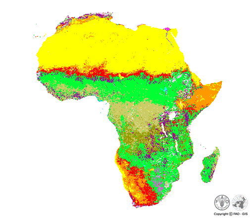
USGS Land cover classification for Africa.
Land cover map based on the U.S. Geological Survey (USGS) classification scheme.
Simple
- Date ( Creation )
- 1998-01-01
- Edition
- First edition.
- Presentation form
- Digital document
- Purpose
- One of a number of datasets that was used to predict fishery potential of inland water bodies in Africa.
- Status
- On going
- Keywords
-
- land use
- Keywords
-
- land suitability
- Keywords
-
- land resources
- Keywords
-
- land management
- Keywords
-
- land evaluation
- Keywords
-
- land classification
- Keywords ( Place )
-
- Africa
- Spatial representation type
- Grid
- Metadata language
- eng
- Character set
- UTF8
- Topic category
-
- Imagery base maps earth cover
- Begin date
- 1998-01-01
N
S
E
W
))
- Supplemental Information
- Reliable for estimates of general land cover patterns at a continental scale. An important limitation is that most classes have two or more disparate land cover classes represented within their spatial distribution. For example, a single class is dryland, cropland and pasture. The wetland land cover category does not include seasonal wetland areas. The urban category is actually the DCW urban areas represented as points. Dataset needs to be validated.
- OnLine resource
-
Online link to a website
(
WWW:LINK-1.0-http- -link
)
Online link to a website
- Hierarchy level
- Dataset
- Description
- Last Updated
- Date / Time
- 2002-05-31 19:58:00
gmd:MD_Metadata
- File identifier
- bb84d8c0-88fd-11da-a88f-000d939bc5d8 XML
- Metadata language
- eng
- Character set
- UTF8
- Date stamp
- 2017-01-11T14:22:50
- Metadata standard name
- ISO 19115:2003/19139
- Metadata standard version
- 1.0
Overviews
large_thumbnail
thumbnail
Spatial extent
N
S
E
W
Provided by

Associated resources
Not available