 FAO Map Catalog
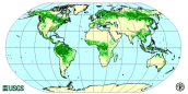
The World's Forests 2000.
The forest cover map is the first comprehensive worldwide view of forests, using a consistent methodology and standard data. The map has a resolution of 1 km and is based on 1992-93 and 1995-96 AVHRR data. Four broad land cover categories are presented following FAO standard classification: closed forest, open/fragmented forest, other wooded land and other land. Due to the coarse source data, the map cannot be used to obtain reliable country forest cover statistics. The final map has been drafted through validation with information/maps based on higher resolution data, e.g. Landsat TM or SPOT images. An accuracy assessment will be carried out in year 2000 to determine the classification accuracy.
Simple
- Date ( Creation )
- 2001-07-01
- Edition
- First edition.
- Presentation form
- Digital map
- Purpose
- The primary use of the map is to show the current extent of forests at a global and regional level. Other potential uses include sampling for forest change assessments and modelling, and to supplement regions lacking recent, reliable forest inventory data.
- Status
- On going
- Keywords
-
- FORESTS
- Tag_forestry
- Keywords
-
- Forest cover
- FRA 2000
- Keywords ( Place )
-
- World
- Spatial representation type
- Grid
- Metadata language
- eng
- Character set
- UTF8
- Topic category
-
- Imagery base maps earth cover
- Environment
- Begin date
- 1992-07-01
- End date
- 1996-07-01
N
S
E
W
))
- Supplemental Information
- The map has been developed at the EROS Data Center (EDC) of the United States of America. The UNEP World Conservation Monitoring Center (UNEP-WCMC) in the United Kingdom has collaborated in the map validation.
- Number of dimensions
- 2
- Dimension name
- Column
- Dimension size
- 4000
- Resolution
- 0.009
- Dimension name
- Row
- Dimension size
- 2000
- Resolution
- 0.009
- Transformation parameter availability
- No
- OnLine resource
-
Link to FAO Forestry website
(
WWW:LINK-1.0-http--link
)
Link to FAO Forestry website
- OnLine resource
-
geonetwork:for_2000_1253
(
OGC:WMS-1.1.1-http-get-map
)
The World's Forests 2000
- OnLine resource
-
for_00.zip
(
WWW:DOWNLOAD-1.0-http--download
)
The World's Forests 2000 - grid file
- OnLine resource
- for_00.axl ( WWW:LINK-1.0-http--link )
- Hierarchy level
- Dataset
- Description
- Last Updated
- Date / Time
- 2002-05-31 19:58:00
gmd:MD_Metadata
- File identifier
- b9f2ee20-88fd-11da-a88f-000d939bc5d8 XML
- Metadata language
- eng
- Character set
- UTF8
- Date stamp
- 2013-10-24T15:02:34
- Metadata standard name
- ISO 19115:2003/19139
- Metadata standard version
- 1.0
Overviews
thumbnail

large_thumbnail
Spatial extent
N
S
E
W
Provided by

Associated resources
Not available