 FAO Map Catalog
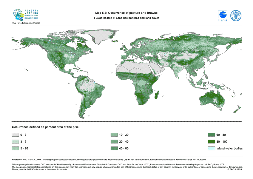
Occurrence of pasture and browse (FGGD)
The FGGD land cover occurrence maps are global raster datalayers with a resolution of 5 arc-minutes. Each pixel in each map contains a value representing the percentage of the area belonging to the land cover type concerned. The method is described in FAO and IIASA, 2007, Mapping biophysical factors that influence agricultural production and rural vulnerability, by H. von Velthuizen et al.
Simple
- Date ( Publication )
- 2007-05-29
- Edition
- 1.0
- Presentation form
- Digital map
- Purpose
- The FGGD Digital Atlas consists of more than 100 global database that allows to analyse food insecurity and poverty in relation to the environment.
- Status
- Completed
Point of contact
FAO - GIS UNIT
-
(
GIS Manager
)
Viale delle Terme di Caracalla, 1
,
Rome
,
00153
,
Italy
- Maintenance and update frequency
- As needed
- Keywords ( Theme )
-
- pasture
- grazing land
- livestock
- Keywords ( Place )
-
- World
- Access constraints
- Copyright
- Use constraints
- Copyright
- Spatial representation type
- Grid
- Metadata language
- eng
- Character set
- UTF8
- Topic category
-
- Imagery base maps earth cover
- Farming
N
S
E
W
))
- Supplemental Information
- This dataset is contained in Module 5 "Land use patterns and land cover" of Food Insecurity, Poverty and Environment Global GIS Database (FGGD) (FAO, 2007).
- Reference system identifier
- GCS_WGS_1984
- Number of dimensions
- 2
- Dimension name
- Row
- Dimension size
- 2160
- Resolution
- 0.08333333 ,
- Dimension name
- Column
- Dimension size
- 4320
- Resolution
- 0.08333333 ,
Axis Dimensions Properties
No information provided.
- Cell geometry
- Area
- Transformation parameter availability
- Yes
- Distribution format
-
-
TIFF
(
)
-
TIFF
(
)
- OnLine resource
-
pasture.zip
(
WWW:DOWNLOAD-1.0-http--download
)
Occurrence of pasture and browse - Grid format (3.19 MB)
- OnLine resource
-
geonetwork:pasture_14068
(
OGC:WMS-1.1.1-http-get-map
)
Occurrence of pasture and browse (FGGD)
Data quality info
No information provided.
gmd:MD_Metadata
- File identifier
- 913e79a0-7591-11db-b9b2-000d939bc5d8 XML
- Metadata language
- eng
- Character set
- UTF8
- Date stamp
- 2023-01-18T16:19:26
- Metadata standard name
- ISO 19115:2003/19139
- Metadata standard version
- 1.0
Point of contact
FAO - GIS UNIT
-
Mirella Salvatore
(
Consultant
)
Via delle Terme di Caracalla, 1
,
Rome
,
00153
,
Italy
Overviews
thumbnail
large_thumbnail
Spatial extent
N
S
E
W
Provided by

Associated resources
Not available