 FAO Map Catalog
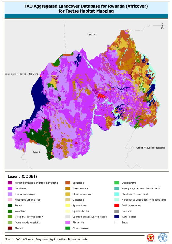
Aggregated landcover database for Rwanda (Africover) for tsetse habitat mapping
This dataset is an aggregated version of the original national Africover landcover multipurpose database.
A 26-class legend is used to aggregate the classes present in the original full resolution, multipurpose landcover database. A single legend is applicable to the eight trypanosomiasis-affected countries mapped during Africover project (Burundi, Democratic Republic of the Congo, Kenya, Rwanda, Somalia, Sudan, Uganda and United Republic of Tanzania).
Simple
- Date ( Creation )
- 2007-05-22
- Edition
- first
- Presentation form
- Digital map
- Purpose
- Thematic aggregation has been performed by the Programme Against African Trypanosomiasis (PAAT) to support mapping of tsetse habitat and decision making in disease affected countries.
- Status
- Completed
- Maintenance and update frequency
- As needed
- Keywords ( Theme )
-
- african tripanosomiasis
- Tag_PAAT
- Keywords ( Place )
-
- Rwanda
- Access constraints
- Copyright
- Spatial representation type
- Vector
- Denominator
- 100000
- Metadata language
- eng
- Character set
- UTF8
- Topic category
-
- Biota
- Health
- Environment
- Farming
))
- Reference system identifier
- WGS 1984
- Distribution format
-
-
ESRI Shapefile
(
1.0
)
-
ESRI Shapefile
(
1.0
)
- OnLine resource
-
Land cover and tsetse fly distributions in sub-Saharan (post-print version)
(
WWW:DOWNLOAD-1.0-ftp--download
)
Land cover and tsetse fly distributions in sub-Saharan (post-print version)
- OnLine resource
-
rw.zip
(
WWW:DOWNLOAD-1.0-http--download
)
Aggregated landcover database for Rwanda (Africover) for tsetse habitat mapping (5.8 Mb)
- OnLine resource
-
rw.qml
(
WWW:DOWNLOAD-1.0-http--download
)
Legend in QuantumGIS format
OnLine resource
OnLine resource
- OnLine resource
-
Standardizing land cover mapping for tsetse and trypanosomiasis decision making
(
WWW:LINK-1.0-http--link
)
Standardizing land cover mapping for tsetse and trypanosomiasis decision making
OnLine resource
- OnLine resource
-
Programme Against African Trypanosomiasis
(
WWW:LINK-1.0-http--link
)
Programme Against African Trypanosomiasis
- OnLine resource
-
Africover website
(
WWW:LINK-1.0-http--link
)
Africover website
gmd:MD_Metadata
- File identifier
- 88ffbea0-1e49-11dc-abdf-000d939bc5d8 XML
- Metadata language
- eng
- Character set
- UTF8
- Date stamp
- 2024-04-22T09:22:26
- Metadata standard name
- ISO 19115:2003/19139
- Metadata standard version
- 1.0
Overviews

Spatial extent
Provided by
