FAO Map Catalog
Aggregated Land Cover Database for Libya
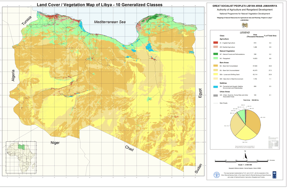
This data set is a re-aggregated version of the full resolution Libyan land cover database. The original full resolution data has been concentrated in few generalized classes highlighting the most relevant features mapped without loosing information. The result is an aggregation of 10 generalized classes listed below, which keeps a good level of information, giving at the same time an exact estimation of the areas covered by each aggregated class.
The 10 Generalized Classes aggregation Land Cover map of Libya:
AGRICULTURE
AI - Irrigated Agriculture
AR - Rainfed Agriculture
NATURAL VEGETATION
NF - Natural Forest and Reforestations
NV - Rangeland
BARE AREAS
BC - Bare Soil Consolidated
BU - Bare Soil Unconsolidated
BSn - Loose and Shifting Sand
BW - Bare Soil in Wadi Environment
SABKHAS
SK - Terrestrial and Aquatic Sabkha Environment and Waterbodies
URBAN AREAS
UB - Urban areas, Quarries and Dump Sites
The land cover products were developed by FAO as part of the LIB/00/04 'Mapping of Natural Resources for Agriculture Use and Planning Project in Libya'. This project was initiated by the Government of Libya, FAO and the United Nations Development Programme (UNDP) to strengthen the capacity of the General People's Committee for Agriculture, Animal and Marine Wealth (GAAAMW) to manage land resources at national and sub-national levels through the establishment of a strategy, and a spatially based operational decision support system - the Land Resources Information Management System (LRIMS).
Simple
- Date ( Publication )
- 2009-04-27T00:00:00
- Edition
- First
- Presentation form
- Digital map
- Purpose
- The purpose of the landcover database is to provide the information required for natural resource assessment and management, environmental modeling and decision-making.
- Status
- Completed
+254-(0)2-4441993
- Keywords ( Theme )
-
- landcover
- environment
- natural resources
- agriculture
- forest
- rangeland
- management
- GLCN
- land cover
- Spatial representation type
- Vector
- Denominator
- 2000000
- Metadata language
- eng
- Character set
- UTF8
- Topic category
-
- Imagery base maps earth cover
- Environment
))
- Supplemental Information
- The original full resolution Land Cover (33,551 polygons covering an interpreted area of 166,560,000 hectares) database has been produced from a visual interpretation of satellite images covering the period 2001-02. The land cover classes (108 LC classes) and the 755 mixed units, deriving from the combination of the single classes, have been standardized using the LCCS methodology.
- Reference system identifier
- Geographic Coordinate System: GCS_WGS_1984
- Distribution format
-
-
ESRI Shapefile
(
1.0
)
-
ESRI Shapefile
(
1.0
)
OnLine resource
OnLine resource
gmd:MD_Metadata
- File identifier
- 7d652a12-4555-4819-bebb-e5beb739f967 XML
- Metadata language
- eng
- Character set
- UTF8
- Date stamp
- 2023-02-02T10:39:15
- Metadata standard name
- ISO 19115:2003/19139
- Metadata standard version
- 1.0
Overviews
Spatial extent
Provided by