 FAO Map Catalog
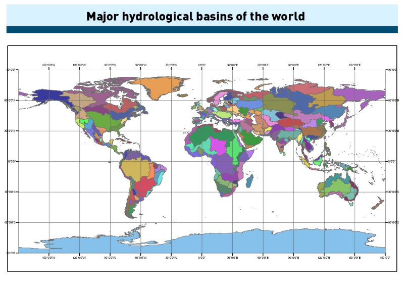
Major hydrological basins of the world
Simple
- Date ( Creation )
- 2011-02-02
- Edition
- First edition
Identifier
- Presentation form
- Digital map
- Other citation details
- Food and Agriculture Organization of the United Nations, FAO Land and Water Division. Major hydrological basins of the world. Latest update: 02/02/2011. Accessed (dd-mm/yy) from: https://data.apps.fao.org/map/catalog/srv/en3c-41cc-8aa5-323d8609b2d1
- Purpose
- To assess which part of the land area flows to which river. The dataset is developed as part of an assessment of water resources, and is also part of the SOLAW (Status of Land and Water Resources for Food and Agriculture) Report.
- Status
- Completed
- Keywords ( Theme )
-
- watersheds
- river basins
- water resources
- hydrology
- AQUASTAT
- fishery
- SOLAW
- land cover
- AQUAMAPS_basins
- Tag_AQUASTAT
- Access constraints
- Copyright
- Use constraints
- License
- Other constraints
- Creative Commons Attribution-NonCommercial-ShareAlike 3.0 IGO (CC BY-NC- SA 3.0 IGO) https://creativecommons.org/licenses/by-nc-sa/3.0/igo/
- Other constraints
- This product "Major hydrological basins of the world" incorporates data from the HydroSHEDS database which is © World Wildlife Fund, Inc. (2006-2013) and has been used herein under license. WWF has not evaluated the data as altered and incorporated within the "Major hydrological basins of the world dataset", and therefore gives no warranty regarding its accuracy, completeness, currency or suitability for any particular purpose.
- Aggregate Datasetindentifier
- e54e2014-d23b-402b-8e73-c827628d17f4
- Association Type
- Part of seamless database
- Initiative Type
- Collection
- Aggregate Datasetindentifier
- 1849e279-67bd-4e6f-a789-9918925a11a1
- Association Type
- Part of seamless database
- Initiative Type
- Collection
- Aggregate Datasetindentifier
- 7ae00a40-642b-4637-b1d3-ffacb13360db
- Association Type
- Part of seamless database
- Initiative Type
- Collection
- Aggregate Datasetindentifier
- ee616dc4-3118-4d67-ba05-6e93dd3e962f
- Association Type
- Part of seamless database
- Initiative Type
- Collection
- Aggregate Datasetindentifier
- b06dc828-3166-461a-a17d-26f4dc9f9819
- Association Type
- Part of seamless database
- Initiative Type
- Collection
- Aggregate Datasetindentifier
- bc9139e6-ccc9-4ded-a0c4-93b91cb54dde
- Association Type
- Part of seamless database
- Initiative Type
- Collection
- Aggregate Datasetindentifier
- d47ba28e-31be-470d-81cf-ad3d5594fafd
- Association Type
- Part of seamless database
- Initiative Type
- Collection
- Aggregate Datasetindentifier
- a1a0e9ee-5062-4950-a6b9-fdd2284b2607
- Association Type
- Part of seamless database
- Initiative Type
- Collection
- Spatial representation type
- Vector
- Denominator
- 5000000
- Metadata language
- eng
- Character set
- UTF8
- Topic category
-
- Geoscientific information
))
- Supplemental Information
- This dataset is developed as part of a GIS-based information system on water resources. It has been published in the framework of the AQUASTAT - programme of the Land and Water Division of the Food and Agriculture Organization of the United Nations. The map is also available in the SOLAW Report 15: “Sustainable options for addressing land and water problems – A problem tree and case studies”.
- Distribution format
-
-
ESRI Shapefile
(
1.0
)
-
ESRI Shapefile
(
1.0
)
- OnLine resource
-
bas_wrld_38047
(
OGC:WMS-1.1.1-http-get-map
)
World map of the major hydrological basins
- OnLine resource
-
Download - Major hydrological basins of the world (ESRI shapefile)
(
WWW:DOWNLOAD-1.0-http--download
)
Download - Major hydrological basins of the world (ESRI shapefile)
- OnLine resource
- General information regarding the HydroSHEDS data product ( WWW:LINK-1.0-http--link )
- OnLine resource
-
HydroSHEDS dataset download and technical information
(
WWW:LINK-1.0-http--link
)
HydroSHEDS dataset download and technical information
- OnLine resource
-
Major rivers of the world
(
WWW:LINK-1.0-http--link
)
Major rivers of the world
- Hierarchy level
- Dataset
- Statement
- The majority of the linework of the map was obtained by delineating drainage basin boundaries from hydrologically corrected elevation data with a resolution of 15 arc-seconds. The elevation dataset was part of a mapping product, HydroSHEDS, developed by the Conservation Science Program of World Wildlife Fund. Original input data had been obtained during NASA's Shuttle Radar Topography Mission (SRTM). Areas north of the SRTM extent, 60 degrees N, were obtained by merging with the HYDRO1k basin layer.
gmd:MD_Metadata
- File identifier
- 7707086d-af3c-41cc-8aa5-323d8609b2d1 XML
- Metadata language
- eng
- Character set
- UTF8
- Hierarchy level
- Dataset
- Date stamp
- 2021-12-16T18:09:15
- Metadata standard name
- ISO 19115:2003/19139
- Metadata standard version
- 1.0
Overviews
Spatial extent
Provided by
