 FAO Map Catalog
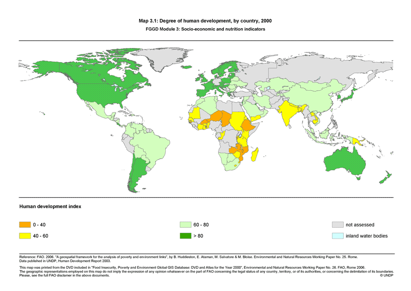
Degree of human development, by country, 2000 (FGGD)
Simple
- Date ( Publication )
- 2007-06-25
- Edition
- 1.0
- Presentation form
- Digital map
- Purpose
- The FGGD Digital Atlas consists of more than 100 global database that allows to analyse food insecurity and poverty in relation to the environment.
- Status
- Completed
- Maintenance and update frequency
- As needed
- Keywords ( Theme )
-
- community development
- social development
- poverty
- low income groups
- Keywords ( Place )
-
- World
- Access constraints
- Copyright
- Use constraints
- Copyright
- Spatial representation type
- Vector
- Metadata language
- eng
- Character set
- UTF8
- Topic category
-
- Society
- Health
))
- Supplemental Information
- This dataset is contained in Module 3 "Socio-economics and nutrition indicators" of Food Insecurity, Poverty and Environment Global GIS Database (FGGD) (FAO, 2007).
- Reference system identifier
- GCS_WGS_1984
- Distribution format
-
-
TIFF
(
)
-
TIFF
(
)
- OnLine resource
-
Map3_1.zip
(
WWW:DOWNLOAD-1.0-http--download
)
Degree of human development, by country, 2000 - vector format (3.9 MB)
- OnLine resource
-
UNDP, 2002. "Human Development Report 2002"
(
WWW:LINK-1.0-http--link
)
UNDP, 2002. "Human Development Report 2002"
- OnLine resource
-
geonetwork:hdi_2000_14117
(
OGC:WMS-1.1.1-http-get-map
)
Degree of human development
Data quality info
gmd:MD_Metadata
- File identifier
- 724f1910-8517-11db-b9b2-000d939bc5d8 XML
- Metadata language
- eng
- Character set
- UTF8
- Date stamp
- 2023-02-02T14:29:25
- Metadata standard name
- ISO 19115:2003/19139
- Metadata standard version
- 1.0
Overviews

Spatial extent
Provided by
