 FAO Map Catalog
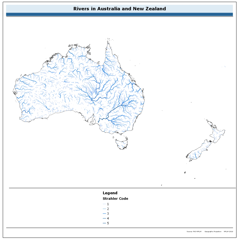
Rivers of Australia and New Zealand
The rivers of Australia and New Zealand dataset is derived from the World Wildlife Fund's (WWF) HydroSHEDS drainage direction layer and a stream network layer. The source of the drainage direction layer was the 15-second Digital Elevation Model (DEM) from NASA's Shuttle Radar Topographic Mission (SRTM). The raster stream network was determined by using the HydroSHEDS flow accumulation grid, with a threshold of about 1000 km² upstream area.
The stream network dataset consists of the following information: the origin node of each arc in the network (FROM_NODE), the destination of each arc in the network (TO_NODE), the Strahler stream order of each arc in the network (STRAHLER), numerical code and name of the major basin that the arc falls within (MAJ_BAS and MAJ_NAME); - area of the major basin in square km that the arc falls within (MAJ_AREA); - numerical code and name of the sub-basin that the arc falls within (SUB_BAS and SUB_NAME); - area of the sub-basin in square km that the arc falls within (SUB_AREA); - numerical code of the sub-basin towards which the sub-basin flows that the arc falls within (TO_SUBBAS) (the codes -888 and -999 have been assigned respectively to internal sub-basins and to sub-basins draining into the sea).
The attributes table now includes a field named "Regime" with tentative classification of perennial ("P") and intermittent ("I") streams.
Simple
- Date ( Revision )
- 2014-03-10T00:00:00
- Edition
- Second edition.
- Presentation form
- Digital map
- Purpose
- To provide a river network with annotated attributes.The dataset is developed as part of an assessment of water resources in Australia and New Zealand.
- Status
- On going
- Keywords ( Theme )
-
- rivers
- fishery
- water resources
- hydrology
- AQUASTAT
- river basins
- AQUAMAPS_rivers
- Tag_AQUASTAT
- Keywords ( Place )
-
- Australia
- Spatial representation type
- Vector
- Denominator
- 5000000
- Metadata language
- eng
- Character set
- UTF8
- Topic category
-
- Geoscientific information
))
- Supplemental Information
- This dataset is developed as part of a GIS-based information system on water resources for Australia and New Zealand. It has been published in the framework of the AQUASTAT - programme of the Land and Water Division of the Food and Agriculture Organization of the United Nations.
- Distribution format
-
-
ESRI Shapefile
(
1.0
)
-
ESRI Shapefile
(
1.0
)
- OnLine resource
-
AQUAMAPS:rivers_australia
(
OGC:WMS-1.1.1-http-get-map
)
Rivers in Australia and New Zealand
- OnLine resource
-
Download - Rivers in Australia and New Zealand (ESRI shapefile)
(
WWW:DOWNLOAD-1.0-http--download
)
Download - Rivers in Australia and New Zealand (ESRI shapefile)
- OnLine resource
-
General information regarding the HydroSHEDS data product
(
WWW:LINK-1.0-http--link
)
General information regarding the HydroSHEDS data product
- OnLine resource
-
HydroSHEDS dataset download and technical information
(
WWW:LINK-1.0-http--link
)
HydroSHEDS dataset download and technical information
- OnLine resource
-
Hydrological basins in Australia and New Zealand
(
WWW:LINK-1.0-http--related
)
Hydrological basins in Australia and New Zealand
- Hierarchy level
- Dataset
- Statement
- The linework of the map was obtained by converting the stream network to a feature dataset with the Hydrology toolset in ESRI ArcGIS.The Flow Direction and Stream Order grids were derived from hydrologically corrected elevation data with a resolution of 15 arc-seconds.The elevation dataset was part of a mapping product, HydroSHEDS, developed by the Conservation Science Program of World Wildlife Fund.Original input data had been obtained during NASA's Shuttle Radar Topography Mission (SRTM).
- Description
- Last Updated
- Date / Time
- 2009-11-04T00:00:00
gmd:MD_Metadata
- File identifier
- 6a53d768-1e20-46ea-92a8-c4040286057d XML
- Metadata language
- eng
- Character set
- UTF8
- Hierarchy level
- Dataset
- Date stamp
- 2021-12-15T16:30:50
- Metadata standard name
- ISO 19115:2003/19139
- Metadata standard version
- 1.0
Overviews
Spatial extent
Provided by
